Luzège
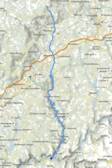
The Luzège (French pronunciation: [lyzɛʒ]; Occitan: Luseja) is a 64.2 km (39.9 mi) long river in the Corrèze département, south-central France.[1] Its source is on the Plateau de Millevaches, in Meymac, 7 km (4.3 mi) north-northwest of the town. It flows generally south. It is a right tributary of the Dordogne, into which it flows just to the south of Laval-sur-Luzège.
| Luzège | |
|---|---|
 | |
 | |
| Location | |
| Country | France |
| Physical characteristics | |
| Source | |
| • location | Meymac |
| • coordinates | 45°35′37″N 02°06′53″E |
| • elevation | 925 m (3,035 ft) |
| Mouth | |
• location | Dordogne |
• coordinates | 45°13′36″N 02°08′25″E |
• elevation | 255 m (837 ft) |
| Length | 64.2 km (39.9 mi) |
| Basin size | 402 km2 (155 sq mi) |
| Discharge | |
| • average | 9.9 m3/s (350 cu ft/s) |
| Basin features | |
| Progression | Dordogne→ Gironde estuary→ Atlantic Ocean |
Communes along its course
This list is ordered from source to mouth: Meymac, Combressol, Maussac, Darnets, Palisse, Lamazière-Basse, Moustier-Ventadour, Saint-Hilaire-Foissac, Lapleau, Saint-Pantaléon-de-Lapleau, Soursac, Laval-sur-Luzège
This article is issued from Wikipedia. The text is licensed under Creative Commons - Attribution - Sharealike. Additional terms may apply for the media files.