Lowmead, Queensland
Lowmead is a rural town and locality in the Gladstone Region, Queensland, Australia.[2][3] In the 2021 census, the locality of Lowmead had a population of 179 people.[4]
| Lowmead Queensland | |||||||||||||||
|---|---|---|---|---|---|---|---|---|---|---|---|---|---|---|---|
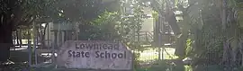 Lowmead State School, 2023 | |||||||||||||||
 Lowmead | |||||||||||||||
| Coordinates | 24.5302°S 151.7527°E | ||||||||||||||
| Population | 179 (SAL 2021)[1] | ||||||||||||||
| Postcode(s) | 4676 | ||||||||||||||
| Area | 333.2 km2 (128.6 sq mi) | ||||||||||||||
| Time zone | AEST (UTC+10:00) | ||||||||||||||
| Location |
| ||||||||||||||
| LGA(s) | Gladstone Region | ||||||||||||||
| State electorate(s) | Burnett | ||||||||||||||
| Federal division(s) | Flynn | ||||||||||||||
| |||||||||||||||
Geography
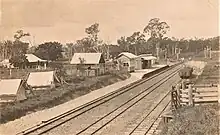
The town is situated in the north of the locality on the North Coast railway line which passes through the north-east of the locality (entering from Berajondo to the south and exiting to Colosseum to the north). The locality is served by:
- Irkanda railway station (24.4914°S 151.7041°E)[5]
- Baffle railway station (24.5473°S 151.7775°E)[5]
The Bruce Highway passes through the south-west of the locality (entering from Kolonga to the south and exiting to Gindoran to the north).[6]
History
In 1887, 14,350 acres (5,810 ha) of land were resumed from the Toweran pastoral run. The land was offered for selection for the establishment of small farms on 17 April 1887.[7]
Lowmead Provisional School opened on 20 May 1908. It was upgraded to a State School in 1911. Due to low enrolments, the school closed on 12 December 1975 but reopened 23 January 1978.[8][9] In January and March 2013, the school was flooded, causing students to miss a number of weeks of school at the start of the school year.[10]
The Lowmead railway station once served the town, but it is now closed.[5] It was west of the junction of Lowmead Road and John Clifford Way (24.52943°S 151.75202°E).[11][12]
Demographics
In the 2011 census, Lowmead had a population of 225 people.[13]
In the 2016 census, the locality of Lowmead had a population of 156 people.[14]
In the 2021 census, the locality of Lowmead had a population of 179 people.[4]
Education
Lowmead State School is a government primary (Prep-6) school for boys and girls at 3077-3083 Lowmead Road (24.5244°S 151.7449°E).[15][16] In 2017, the school had an enrolment of 14 students with 2 teachers (1 full-time equivalent) and 4 non-teaching staff (2 full-time equivalent).[17]
There are no secondary schools in Lowmead. The nearest secondary school is Rosedale State School (to Year 12) in neighbouring Rosedale to the east.[6]
Notable residents
- Trevor Coomber, politician
- Daniel Keighran, soldier
References
- Australian Bureau of Statistics (28 June 2022). "Lowmead (Suburb and Locality)". Australian Census 2021 QuickStats. Retrieved 28 June 2022.
- "Lowmead – town in Gladstone Region (entry 20194)". Queensland Place Names. Queensland Government. Retrieved 26 January 2020.
- "Lowmead – locality in Gladstone Region (entry 46610)". Queensland Place Names. Queensland Government. Retrieved 26 January 2020.
- Australian Bureau of Statistics (28 June 2022). "Lowmead (SAL)". 2021 Census QuickStats. Retrieved 28 February 2023.
- "Railway stations and sidings - Queensland". Queensland Open Data. Queensland Government. 2 October 2020. Archived from the original on 5 October 2020. Retrieved 5 October 2020.
- "Queensland Globe". State of Queensland. Retrieved 1 August 2023.
- "Proclamations under the New Land Acts". The Brisbane Courier. Queensland, Australia. 2 March 1877. p. 3. Archived from the original on 27 August 2020. Retrieved 20 February 2020 – via Trove.
- "Opening and closing dates of Queensland Schools". Queensland Government. Retrieved 2 July 2014.
- "Agency ID 5426, Lowmead State School". Queensland State Archives. Retrieved 4 July 2014.
- Edwards, Alyce (18 March 2014). "Flood-hit students offered 'special consideration'". Australian Broadcasting Corporation. Archived from the original on 15 July 2014. Retrieved 3 July 2014.
- "County of Flinders" (Map). Queensland Government. 1922. Archived from the original on 1 August 2023. Retrieved 1 August 2023.
- "Parish of Warro" (Map). Queensland Government. 1971. Archived from the original on 1 August 2023. Retrieved 1 August 2023.
- Australian Bureau of Statistics (31 October 2012). "Lowmead (SSC)". 2011 Census QuickStats. Retrieved 2 July 2014.
- Australian Bureau of Statistics (27 June 2017). "Lowmead (SSC)". 2016 Census QuickStats. Retrieved 20 October 2018.
- "State and non-state school details". Queensland Government. 9 July 2018. Archived from the original on 21 November 2018. Retrieved 21 November 2018.
- "Lowmead State School". Archived from the original on 21 February 2020. Retrieved 21 November 2018.
- "ACARA School Profile 2017". Archived from the original on 22 November 2018. Retrieved 22 November 2018.
Further reading
- Peeps into the past of Lowmead District : Lowmead State School golden jubilee : 1908-1958, Lowmead State School, 1958, retrieved 1 August 2023