Loch Osgaig
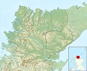
Loch Osgaig (Loch Owskeich) is a small remote and deep freshwater loch, orientated on north-west to south-east axis, that is located 1 miles south of Enard Bay and 2 mile northeast of Achiltibuie[3] and immediately north west of Loch Bad a' Ghaill.[1] It is located in the Coigach peninsula[4] in Lochbroom, Wester Ross.[1][2]

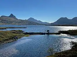
Upturned boat on Loch Osgaig. Looking at the right is the twin peaks of Sgorr Tuath and Sgorr Deas. In the middle is the foreground peak of Stac Pollaidh to the left and Cùl Beag behind. To the left is the peak of Cùl Mòr
| Loch Osgaig | |
|---|---|
 The top pool of the River Osgaig below Loch Bad a' Ghaill | |
 Loch Osgaig Location in Wester Ross | |
| Location | NC04461204 |
| Coordinates | 58.05419°N 5.3155°W |
| Type | freshwater loch |
| Primary inflows | Abhainn Osgaig |
| Primary outflows | Unnamed burn into Garvie Bay |
| Max. length | 2.4 km (1.5 mi)[1] |
| Max. width | 1.2 km (0.75 mi)[1] |
| Surface area | 168 ha (420 acres)[2] |
| Average depth | 47 ft (14 m)[1] |
| Max. depth | 153 ft (47 m)[1] |
| Water volume | 846,990,604.059 cu ft (23,984,103.0000 m3)[2] |
| Shore length1 | 7 km (4.3 mi) [2] |
| Surface elevation | 26 m (85 ft)[2] |
| Max. temperature | 54.8 °F (12.7 °C) |
| Min. temperature | 50.8 °F (10.4 °C) |
| 1 Shore length is not a well-defined measure. | |
References
- John, Murray; Lawrence, Pullar. Bathymetrical Survey of the Fresh-Water Lochs of Scotland, 1897–1909 Lochs of the Polly Basin Volume II – Loch Osgaig. p. 173. Retrieved 23 June 2023.
 This article incorporates text from this source, which is in the public domain.
 - "Loch Osgaig". Centre for Ecology and Hydrology. Scotland and Northern Ireland Forum for Environmental Research (SNIFFER). Retrieved 23 June 2023.
- Gittings, Bruce; Munro, David. "Loch Osgaig". The Gazetteer for Scotland. School of GeoSciences, University of Edinburgh and The Royal Scottish Geographical Society. Retrieved 24 June 2023.
- Andrews, Robert (2004). The Rough Guide to Britain. Rough Guides. p. 1240. ISBN 978-1-84353-301-6.
This article is issued from Wikipedia. The text is licensed under Creative Commons - Attribution - Sharealike. Additional terms may apply for the media files.