List of fracture zones
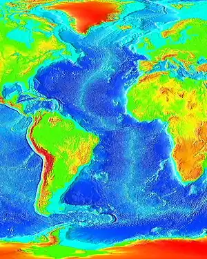
Fracture zones are common features in the geology of oceanic basins. Globally most fault zones are located on divergent plate boundaries on oceanic crust. This means that they are located around mid-ocean ridges and trend perpendicular to them. The term fracture zone is used almost exclusively for features on oceanic crust; similar structures on continental crust are instead termed transform or strike slip faults, a denomination active fracture zones also can have. Not all named fracture zones are active, but can be significant ocean floor features due to past tectonic processes. Some fracture zones have been created by mid-ocean ridge segments that have been subducted and may not longer exist.
Pacific Ocean
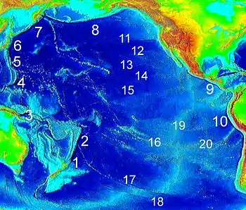
Most fracture zones in the Pacific Ocean originate from large mid-ocean ridges (also called "rises") such as the East Pacific Rise, Chile Rise and Juan de Fuca Ridge. The plates that host the fractures are Nazca, Pacific, Antarctic, Juan de Fuca and Cocos among others. Fracture zones being subducted under Southern and Central America are generally southwest-northeast oriented reflecting the relative motion of Cocos, Nazca and the Antarctic Plates.
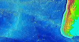
Chile Rise
The fracture zones of the Chile Rise trend in a west to east fashion with the most southern ones taking a slightly more southwest to northeast orientation. This non-perpendicular relation to Chile's coast reflects the oblique subduction of Nazca Plate under southern Chile. West of Chile rise the fracture zones are hosted in the Antarctic Plate. Some fracture zones such as Chile and Valdivia make up large sections of the Nazca-Antarctic Plate boundary.
| Name | Minimum length in km | Length of transform boundary in km | Position at Ridge |
|---|---|---|---|
| Chile Fracture Zone | 2,250 (1,400) | 1,100 (680) | 35°32′24″S 104°37′3″W |
| Chiloé Fracture Zone | 1,750 (1,090) | 50 (30) | 42°59′43″S 83°11′5″W |
| Darwin Fracture Zone | 50 (30) | 45°54′29″S 76°25′31″W | |
| Desolación Fracture Zone | 0 | ||
| Esmeralda Fracture Zone | 0 | 49°06′47″S 80°12′33″W | |
| Guafo Fracture Zone | 1,550 (960) | 280 (170) | 44°47′55″S 80°15′53″W |
| Guambin Fracture Zone | 1,300 (810) | 70 (40) | 45°44′7″S 77°27′32″W |
| Madre de Dios Fracture Zone | 0 | ||
| Mocha Fracture Zone | 450 (280) | 0 | 39°14′24″S 77°22′59″W |
| Taitao Fracture Zone | 0 | ||
| Tres Montes Fracture Zone | 0 | ||
| Valdivia Fracture Zone | 2,100 (1,300) | 650 (400) | 41°23′25″S 87°23′36″W |
East Pacific Rise
| Name | Minimum length in km | Length as plate boundary in km | Coordinates |
|---|---|---|---|
| Easter Fracture Zone | |||
| Mendaña Fracture Zone | 0 | ||
| Nazca Fracture Zone | 0 | 19°49′28″S 77°35′53″W | |
| Quiros Fracture Zone | 0 |
Galapagos Rise
West of East Pacific Rise and Gulf of California Rift Zone
(some are inactive)[1]
- Challenger Fracture Zone
- Austral Fracture Zone[1]
- Marquesas Fracture Zone[1]
- Galapagos Fracture Zone[1]
- Clipperton Fracture Zone[1]
- Clarion Fracture Zone[1]
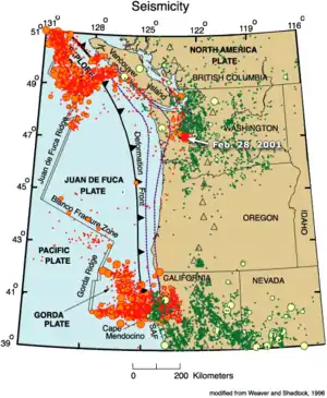
Juan de Fuca and Gorda Ridges
Surveyor, Molokai, Pioneer and Murray fracture zones shown in the list were created by ridge segments that no longer exist.[1]
- Blanco Fracture Zone
- Surveyor Fracture Zone[1]
- Mendocino Fracture Zone[1]
- Pioneer Fracture Zone[1]
- Murray Fracture Zone[1]
- Molokai Fracture Zone[1]
- Sovanco Fracture Zone
Atlantic Ocean
In the Atlantic Ocean most fracture zones originate from the Mid-Atlantic Ridge, which runs from north to south, and are therefore west to east oriented in general. There are about 300 fracture zones, with an average north-south separation of 55 kilometres (34 mi):[2] two for each degree of latitude. Physically it makes sense to group Atlantic fracture zones into three categories:[3]
- Small offset: length of transform fault less than 30 kilometres (19 mi)
- Medium offset: offset over 30 kilometers
- Large offset: offset several hundreds of kilometers
Mid-Atlantic Ridge (Northern Hemisphere)
| Name | Minimum length in km | Length of transform fault in km | Position at Ridge |
|---|---|---|---|
| Saint Paul Fracture Zone[4] | 1451 | 454 | 0.661°N 27.931°W |
| Saint Peter Fracture Zone[4] | 333 | 40 | 2.532°N 31.008°W |
| Strakhov Fracture Zone[4] (formerly:Four North[5]) | 1814 | 100 | 3.933°N 32.116°W |
| Sierra Leone Fracture Zone[4] | 1111 | 52 | 6.230°N 33.588°W |
| Bogdanov Fracture Zone[4] | 173 | 84 | 7.135°N 34.351°W |
| Vernadsky Fracture Zone[4] | 194 | 107 | 7.693°N 37.483°W |
| Doldrums Fracture Zone[4] | 381 | 144 | 8.119°N 38.750°W |
| Arkhangelskiy Fracture Zone[4] | 691 | 99 | 8.855°N 39.938°W |
| Vema Fracture Zone[4] | 822 | 300 | 10.726°N 42.333°W |
| Mercurius[6] | 39 | 12.132°N 43.924°W | |
| Marathon Fracture Zone[6] | 78 | 12.611°N 44.430°W | |
| Fifteen Twenty Fracture Zone, also known as Barracuda or Cabo Verde[4] | 1195 | 195[6] | 15.320°N 45.871°W |
| Vidal Fracture Zone[3] | 50 | 17.832°N 46.589°W | |
| Luymes South Fracture Zone[3] | 30 | 18.541°N 46.465°W | |
| Luymes North Fracture Zone[3] | 24 | 18.967°N 46.128°W | |
| Snellius Fracture Zone[3] | 41 | 20.616°N 45.756°W | |
| Kane Fracture Zone[4] | 1040 | 150[7] | 23.718°N 45.583°W |
| Northern Fracture Zone[3] | 1040 | 9 | 25.689°N 45.193°W |
| Tyro Fracture Zone[3] | 15 | 29.365°N 43.007°W | |
| Atlantis Fracture Zone[4] | 843 | 66 | 30.068°N 42.372°W |
| Cruiser Fracture Zone[3] | 9 | 32.323°N 40.195°W | |
| Charis Fracture Zone[3] | 13 | 33.059°N 39.628°W | |
| Hayes Fracture Zone[4] | 624 | 151 | 33.615°N 38.439°W |
| Oceanographer Fracture Zone[4] | 751 | 148 | 35.149°N 35.562°W |
| Tydeman Fracture Zone | 21 | 36.641°N 33.464°W | |
| Pico Fracture Zone (to the west)[3][4] | 719 | 67 | 37.468°N 31.899°W |
| East Azores Fracture Zone (to the east)[3][4] | 758 | 67 | 37.468°N 31.899°W |
| Kurchatov Fracture Zone[4] | 174 | 20 | 40.537°N 29.456°W |
| Petrov Fracture Zone[4] | 74 | 9 | 40.537°N 29.456°W |
| Maxwell Fracture Zone[4] | 21 | 47.636°N 27.527°W | |
| Faraday Fracture Zone[4] | 506 | 23 | 49.711°N 28.636°W |
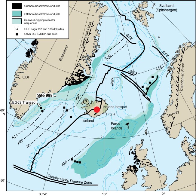
| Charlie-Gibbs Fracture Zone[4] | 2000 | 350[3] | 52.624°N 33.198°W |
| Bight Fracture Zone[4] | 336 | 23 | 56.721°N 33.792°W |
| Jan Mayen Fracture Zone[4] | 374 | 211 | 71.372°N 9.405°E |
| Greenland Fracture Zone (to the west)[8] | 0 | 365 | 74.04°N 8.82°E |
| Senja Fracture Zone (to the east)[8] | 0 | 398 | 74.04°N 8.82°E |
Fracture zones involved in the early opening of the North Atlantic
| American side | African side |
|---|---|
| Hudson Fracture Zone | |
| Snorri Fracture Zone | |
| Cartwright Fracture Zone | |
| Julian Haab Fracture Zone | |
| Minna Fracture Zone | |
| Leif Fracture Zone | |
| Newfoundland Fracture Zone[9] | |
| Kelvin Fracture Zone[10] | Canary Fracture Zone[10] |
| Cape Fear Fracture Zone[10] | Cape Verde Fracture Zone[10] |
| Bahama Fracture Zone[10] | Guinea Fracture Zone[10] |
Mid-Atlantic Ridge (Southern Hemisphere)
| Name | Minimum length in km | Length of transform fault in km | Position at Ridge |
|---|---|---|---|
| Romanche Fracture Zone[4] | 2445 | 950 | 0.49°S 20.49°W |
| Chain Fracture Zone[4] | 1315 | 269 | 1.213°S 14.229°W |
| Ascension Fracture Zone[4] | 1149 | 264 | 6.928°S 12.283°W |
| Bode Verde Fracture Zone[4] | 3018 | 232 | 11.686°S 13.936°W |
| Cardno Fracture Zone[4] | 1649 | 87 | 14.076°S 14.056°W |
| Tetyaev Fracture Zone[4] | 810 | 122 | 16.271°S 13.719°W |
| Saint Helena Fracture Zone[4] | 1184 | 19 | 16.617°S 14.344°W |
| Hotspur Fracture Zone[4] | 1446 | 113 | 17.721°S 13.329°W |
| Martin Vaz Fracture Zone[4] | 1324 | 26 | 18.594°S 12.633°W |
| Rio Grande Fracture Zone[4] | 1774 | 156 | 29.081°S 13.067°W |
| Tristan Da Cunha Fracture Zone[4] | 1014 | 26 | 38.388°S 16.796°W |
| Gough Fracture Zone[4] | 1057 | 42 | 40.637°S 16.637°W |
| Conrad Fracture Zone (to the west)[4] | 316 | 0 | 55.185°S 0.133°W |
| Bouvet Fracture Zone (to the east)[4] | 198 | 0 | 55.185°S 0.133°W |
Indian Ocean
Southwest Indian Ridge
- Bouvet Fracture Zone
- Moshesh Fracture Zone
- Islas Orcadas Fracture Zone
- Shaka Fracture Zone
- Dutoit Fracture Zone
- Prince Edward Fracture Zone
- Discovery II Fracture Zone
- Indomed Fracture Zone
- Gallieni Fracture Zone
- Atlantis II Fracture Zone[11]
- Novara Fracture Zone[11]
- Melville Fracture Zone[11]
Carlsberg Ridge
Central Indian Ridge
- Mauritius Fault Zone
Lakshadweep-Chagos Ridge
- Vishnu Fault Zone
Southern Ocean
- Endurance Fault Zone
- Eltanin Fault System
- Hjort Fracture Zone
- Hero Fault Zone
- Kosminskaya Fracture Zone
- Quest Fault Zone
- Pitman Fracture Zone
- Shackleton Fracture Zone
- Vinogradov Fracture Zone
References
- Kruse, SE; McCarthy, MC; Brudzinski, MR; Ranieri, ME (10 June 1996). "Evolution and strength of Pacific fracture zones". Journal of Geophysical Research: Solid Earth. 101 (B6): 13731–40. doi:10.1029/96JB00645.
- Gilman, Larry; Lerner, K. Lee. "Mid-Ocean-Ridges". Water Encyclopedia. Retrieved 2011-11-29.
- Müller, R. Dietmar; Roest, Walter R. (1992). "Fracture Zones in the North Atlantic from Combined Geosat and Seasat Data" (PDF). Journal of Geophysical Research. 97 (B3): 3337–50. Bibcode:1992JGR....97.3337M. doi:10.1029/91JB02605. Archived from the original (PDF) on 2012-03-28. Retrieved 2011-11-30.
- Name from GEBCO gazetteer, position refined by means of etopo2 and sample data of GPlates
- Udintsev, G.B. (1996). "Equatorial Segment of the Mid-Atlantic Ridge". Unesco. Archived from the original on 2012-09-07. Retrieved 2011-12-05.
- Roest, W. R.; Collette, B. J. (1986). "The Fifteen Twenty Fracture Zone and the North American – South American plate boundary". Journal of the Geological Society. 143 (5): 833–43. Bibcode:1986JGSoc.143..833R. doi:10.1144/gsjgs.143.5.0833. S2CID 128413673.
- Tucholke, Brian E.; Schouten, Hans (1988-03-01). "Kane Fracture Zone". Marine Geophysical Research. 10 (1–2): 1–39. Bibcode:1988MarGR..10....1T. doi:10.1007/BF02424659. S2CID 129456202.
- "Map with Jan Mayen, Greenland and Senja Fracture Zones". Ocean Drilling Project. Retrieved 2011-12-16.
- Auzende, J.M.; Olivet, J.L.; Bonnin, J. (1970). "Marge du Grand Bank et la fracture de Terre-Neuve". Compt. Rend. (in French). 271: 1063–66.
- Le Pichon, Xavier; Fox, Paul J. (1971-09-10). "Marginal Offsets, Fracture Zones, and the Early Opening of the North Atlantic". Journal of Geophysical Research. 76 (26): 6294–308. Bibcode:1971JGR....76.6294L. doi:10.1029/JB076i026p06294.
- Patriat, P., Sauter, D., Munschy, M., & Parson, L. (1997). A survey of the Southwest Indian Ridge axis between Atlantis II Fracture Zone and the Indian Ocean Triple Junction: Regional setting and large scale segmentation. Marine Geophysical Researches, 19(6), 457–80.
- Sources