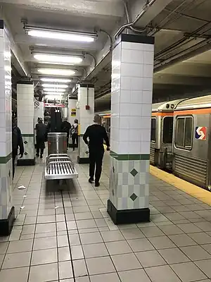
List of Philadelphia subway stations
Philadelphia has three rapid transit lines: two operated by the Southeastern Pennsylvania Transportation Authority (SEPTA) and one by the PATCO Speedline. The two SEPTA lines operate mostly in Philadelphia with two stations in Delaware County, Pennsylvania. The PATCO line connects Philadelphia and Camden County, New Jersey.

Broad Street Line
Market–Frankford Line
| Station | Miles (km) | Connections | Weekday Ridership (2018)[2] |
Notes |
|---|---|---|---|---|
| 69th Street Transportation Center | 0.0 (0) | 17,680 | Western terminus, in Upper Darby, PA | |
| Millbourne | 0.4 (0.6) | 489 | Originally named 66th Street | |
| 63rd Street | 0.8 (1.3) | 2,236 | ||
| 60th Street | 1.1 (1.8) | 5,432 | Rebuilt station opened June 18, 2007 | |
| 56th Street | 1.5 (2.4) | 6,238 | Rebuilt station opened February 27, 2006 | |
| 52nd Street | 1.9 (3.1) | 7,498 | ||
| 46th Street | 2.5 (4.0) | 5,011 | Rebuilt station opened April 14, 2008 | |
| 40th Street | 3.2 (5.1) | 6,624 | Original station was elevated | |
| 34th Street | 3.7 (6.0) | 7,076 | Original station at 36th Street was elevated | |
| 30th Street | 4.1 (6.6) | 7,704 | Original station at 32nd Street was elevated | |
| 15th Street | 5.1 (8.2) | 34,384 | Access to City Hall | |
| 13th Street | 5.4 (8.7) | 8,146 | Eastern terminal for trolley lines Access to Wanamaker Building | |
| 11th Street | 5.6 (9.0) | 8,629 | Access to Jefferson Station and Fashion District Philadelphia | |
| 8th Street | 5.8 (9.3) | 11,019 | ||
| 5th Street/Independence Hall | 6.0 (9.7) | 3,986 | Access to Independence NHP. | |
| 2nd Street | 6.3 (10.1) | 3,928 | Access to Old City District and Penn's Landing | |
| Spring Garden | 7.1 (11.4) | 3,275 | Replaced Fairmount station in 1977 | |
| Girard | 7.8 (12.6) | 5,154 | ||
| Berks | 8.5 (13.7) | 2,653 | ||
| York–Dauphin | 8.9 (14.3) | 1,738 | Original name was Dauphin-York | |
| Huntingdon | 9.3 (15.0) | 2,956 | ||
| Somerset | 9.6 (15.4) | 2,246 | ||
| Allegheny | 10.2 (16.4) | 6,109 | ||
| Tioga | 10.6 (17.1) | 1,881 | Original northbound station building is preserved. | |
| Erie–Torresdale | 11.3 (18.2) | 4,544 | Originally named Torresdale | |
| Church | 11.8 (19.0) | 1,291 | Originally named Ruan–Church | |
| Arrott Transportation Center | 12.3 (19.8) | 4,737 | Named Margaret–Orthodox until 2014. Originally named Margaret–Orthodox–Arrott. | |
| Frankford Transportation Center | 12.9 (20.8) | 19,052 | Eastern terminus, station replaced Bridge–Pratt |
PATCO Speedline
| State | Location | Station | Connections | Notes |
|---|---|---|---|---|
| PA | Rittenhouse Square, Philadelphia | 15–16th & Locust |
|
Access to Downtown Link concourse, which connects to 15th Street, City Hall, Suburban, and Walnut–Locust stations |
| Washington Square West, Philadelphia | 12–13th & Locust | |||
| 9–10th & Locust |
Station closed 12:15am–4:45am | |||
| Center City, Philadelphia | 8th & Market |
|||
| Franklin Square | Closed since 1979 (planned reopening April 2024)[3][4][5] | |||
| NJ | Downtown, Camden | City Hall | Station closed 12am–5am[6][7] | |
| Broadway |
All connections via Walter Rand Transportation Center | |||
| Whitman Park, Camden | Ferry Avenue |
|||
| Collingswood | Collingswood |
|||
| Haddon Township | Westmont |
|||
| Haddonfield | Haddonfield |
|||
| Cherry Hill | Woodcrest |
Has three tracks for short turn service to/from Philadelphia, exit 31 of I-295 provides direct station access | ||
| Voorhees | Ashland |
|||
| Lindenwold | Lindenwold |
The PATCO Speedline connects to eight other stations outside of Philadelphia.
References
- "Fiscal Year 2020 Annual Service Plan" (PDF). SEPTA. July 2019. Retrieved September 27, 2020.
- "Fiscal Year 2020 Annual Service Plan" (PDF). SEPTA. July 2019. Retrieved September 27, 2020.
- "Patco Will Apply For Federal Funds To Get Dormant Franklin Square PATCO Station Reopened". CBS Philly. CBS Local Media. May 21, 2015. Retrieved September 25, 2015.
- "PATCO's Philly Ghost Station Just Got Closer to Reopening". September 21, 2017.
- "PATCO | Projects". www.ridepatco.org. Retrieved September 22, 2018.
- "PATCO – Alerts". www.ridepatco.org. Archived from the original on 8 September 2022. Retrieved 8 September 2022.
- "PATCO – City Hall". www.ridepatco.org. Archived from the original on 8 September 2022. Retrieved 8 September 2022.
This article is issued from Wikipedia. The text is licensed under Creative Commons - Attribution - Sharealike. Additional terms may apply for the media files.