Letterbrat
Letterbrat is a townland in County Tyrone, Northern Ireland. It is situated in the barony of Strabane Upper and the civil parish of Bodoney Upper and covers an area of 708 acres.[1]
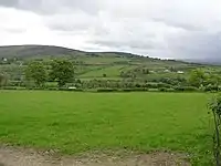
Letterbrat townland in 2009
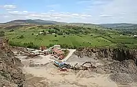
Letterbrat Quarry in 2007
The name derives from the Irish: Lathair Beith (Place for birch trees), Litir brat (hill of the cloaks) or leiter brat (wet sloping land of the brats/mantle).[2]
In 1841 the population of the townland was 222 people (41 houses) and in 1851 it was 182 people (32 houses).[3]
The townland contains one Scheduled Historic Monument: a Portal tomb (grid ref: H4715 9156).[4]
The townland also contains Letterbrat Quarry (grid ref: H471923) where the very old grey quartz-rich rock is worked for road stone. The quarry also features a very thick intrusion of porphyry.[5]
See also
Wikimedia Commons has media related to Letterbrat.
References
- "Townlands of County Tyrone". IreAtlas Townland Database. Retrieved 20 December 2012.
- "Letterbrat". Place Names NI. Retrieved 20 December 2012.
- "Census of Ireland 1851". Enhanced Parliamentary Papers on Ireland. Retrieved 20 December 2012.
- "Scheduled Historic Monuments (to 15 October 2012)" (PDF). NI Environment Agency. Archived from the original (PDF) on 26 October 2013. Retrieved 20 December 2012.
- "Letterbrat Quarry". Habitas. Geological sites in Northern Ireland. Retrieved 20 December 2012.
This article is issued from Wikipedia. The text is licensed under Creative Commons - Attribution - Sharealike. Additional terms may apply for the media files.