Lac d'Aiguebelette
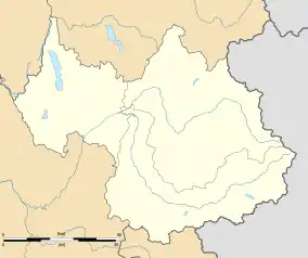
Lac d'Aiguebelette is a natural lake in the commune of Aiguebelette-le-Lac, within the department of Savoie, France.
| Lac d'Aiguebelette | |
|---|---|
 | |
 Lac d'Aiguebelette | |
 | |
| Location | Savoie |
| Coordinates | 45°33′10″N 5°47′50″E |
| Primary inflows | Leysse de Novalaise |
| Primary outflows | Tiers |
| Catchment area | 70 km2 (27 sq mi) |
| Basin countries | France |
| Surface area | 5.45 km2 (2.10 sq mi) |
| Max. depth | 71 m (233 ft) |
| Water volume | 166×106 m3 (135,000 acre⋅ft) |
| Surface elevation | 390.5 m (1,281 ft) |
| Frozen | 1909, 1929, 1941, 1942, 1956 |
| Islands | 2 |
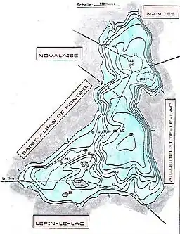
| Settlements | Aiguebelette, Lépin-le-Lac, Saint-Alban-de-Montbel, Novalaise, Nances |
Geography
Description
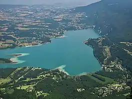
With a surface area of 5.45 km2 and a depth of 71 meters it is one of the largest natural lakes of France. It is noted for its blue-green colour and the seven hot water springs. The communities of Novalaise, Lépin-le-Lac, Saint-Alban-de-Montbel and Aiguebelette-le-Lac border west side of the lake, whilst the Chaîne de l'Épine ridge lies to the east with its high point at Mont Grêle (1,425 metres (4,675 ft)).
At the southern end there are two islands, La Petite Ile and La Grande Ile which has a chapel.
Climate
Lake Aiguebelette has a oceanic climate (Köppen climate classification Cfb) closely bordering on a humid subtropical climate (Cfa). The average annual temperature in Lake Aiguebelette is 11.8 °C (53.2 °F). The average annual rainfall is 1,306.8 mm (51.45 in) with May as the wettest month. The temperatures are highest on average in July, at around 21.2 °C (70.2 °F), and lowest in January, at around 2.7 °C (36.9 °F). The highest temperature ever recorded in Lake Aiguebelette was 36.9 °C (98.4 °F) on 24 July 2019; the coldest temperature ever recorded was −14.3 °C (6.3 °F) on 20 December 2009.
| Climate data for Lac d'Aiguebelette (1991−2020 normals, extremes 2004−2021) | |||||||||||||
|---|---|---|---|---|---|---|---|---|---|---|---|---|---|
| Month | Jan | Feb | Mar | Apr | May | Jun | Jul | Aug | Sep | Oct | Nov | Dec | Year |
| Record high °C (°F) | 18.1 (64.6) |
20.2 (68.4) |
24.3 (75.7) |
28.5 (83.3) |
32.3 (90.1) |
35.9 (96.6) |
36.9 (98.4) |
36.2 (97.2) |
31.8 (89.2) |
27.0 (80.6) |
24.1 (75.4) |
19.6 (67.3) |
36.9 (98.4) |
| Average high °C (°F) | 5.9 (42.6) |
7.6 (45.7) |
12.3 (54.1) |
17.3 (63.1) |
20.4 (68.7) |
24.9 (76.8) |
27.4 (81.3) |
26.3 (79.3) |
22.3 (72.1) |
17.2 (63.0) |
10.8 (51.4) |
6.4 (43.5) |
16.6 (61.9) |
| Daily mean °C (°F) | 2.7 (36.9) |
3.5 (38.3) |
7.3 (45.1) |
11.6 (52.9) |
15.0 (59.0) |
19.1 (66.4) |
21.2 (70.2) |
20.4 (68.7) |
17.0 (62.6) |
12.8 (55.0) |
7.2 (45.0) |
3.3 (37.9) |
11.8 (53.2) |
| Average low °C (°F) | −0.5 (31.1) |
−0.6 (30.9) |
2.2 (36.0) |
5.8 (42.4) |
9.5 (49.1) |
13.3 (55.9) |
15.0 (59.0) |
14.5 (58.1) |
11.7 (53.1) |
8.4 (47.1) |
3.6 (38.5) |
0.1 (32.2) |
6.9 (44.4) |
| Record low °C (°F) | −9.3 (15.3) |
−13.6 (7.5) |
−13.0 (8.6) |
−2.9 (26.8) |
0.4 (32.7) |
3.0 (37.4) |
8.2 (46.8) |
7.8 (46.0) |
4.4 (39.9) |
−1.6 (29.1) |
−8.4 (16.9) |
−14.3 (6.3) |
−14.3 (6.3) |
| Average precipitation mm (inches) | 107.6 (4.24) |
88.5 (3.48) |
110.2 (4.34) |
94.6 (3.72) |
141.6 (5.57) |
110.2 (4.34) |
105.2 (4.14) |
112.1 (4.41) |
89.3 (3.52) |
109.1 (4.30) |
111.4 (4.39) |
127.0 (5.00) |
1,306.8 (51.45) |
| Average precipitation days (≥ 1.0 mm) | 11.3 | 9.3 | 12.1 | 9.4 | 12.5 | 9.8 | 8.3 | 9.3 | 7.6 | 9.7 | 10.3 | 12.6 | 122.1 |
| Source: Météo-France[1] | |||||||||||||
Recreation
The Chaîne de l'Épine ridge is crossed by hiking trails, and paragliders launch from there during the summer.
Motorboats are not allowed on the lake to preserve the silence and wildlife along the lake. There are noted views of the lake from the church at St. Alban de Montbel and the mountain ridges.
Rowing
The lake hosted the 1997[2] and 2015 World Rowing Championships.[3]
References
- "Fiche Climatologique Statistiques 1991-2020 et records" (PDF) (in French). Météo-France. Retrieved September 6, 2022.
- "Rowing History - 1997World Championships". Archived from the original on 2015-09-24. Retrieved 2013-02-18.
- WorldRowing, News. FISA announces selection for the 2015 world rowing championships