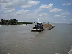
Long Tau river
Lòng Tàu River, Vietnamese: Sông Lòng Tàu) also known as Lòng Tảo is a river in the Mekong Delta of Vietnam.
| Lòng Tàu River | |
|---|---|
 Vessel moving along the Long Tau River | |
| Native name | Sông Lòng Tàu (Vietnamese) |
| Location | |
| Country | Vietnam |
| Basin features | |
| River system | Mekong River |
Description
Long Tau River is a distributary of the Dong Nai river that runs through Can Gio and feeds into Gành Rái Bay from its eastern branch at 10°40′10″N 106°47′24″E.[1] It branches out when it reaches Nhon Trach district, with the western branch becoming the Dong Tranh river into Soai Rap while the eastern branch is a continuation of the Long Tau.[2] Due to its complex and windy path, a system of skeletal range light towers are stationed along the river to help ship navigate.[3] The Phuoc Khanh Bridge is currently under construction and will span the river[4]
Overall, it runs for 75 kilometers from where it splits from the Dong Nai River and continues into Ganh Rai Bay.[5] It has an average depth of 15 meters, running along the Cần Giờ Mangrove Forest before emptying out into the Ocean. [6]
History
As one of the primary waterways between Ho Chi Minh City and the Pacific Ocean, the Long Tau River has played a prominent economic and military role in the region.[7][6][8] Its strategic location has made it the host of prominent warships and military operations and many times a strategic target for both attack and defense.[6]
It currently connects to the Cai Mep deepwater port[9] with a second container port in the works. [10] The main route between Ho Chi Minh City and the Cai Mep terminal for vessels and barges is separately known as Long Tau Channel.[11] As the case with many high-traffic rivers of the Mekong Delta, the banks of Long Tau River are lined with factories.[12][13]
There have been a number of shipwrecks on record, including the sinking of the Vietsun Integrity cargoship in 2019.[14]
Aside from a transport-focus waterway, the river also has had villages along its riverbanks, though there have been ongoing plans towards the economic development of the Can Gio communities.[15] Despite its traffic, it remains a spot for fishermen.[16]
References
- "Quyết định 1989/QĐ-TTg Danh mục lưu vực sông liên tỉnh". THƯ VIỆN PHÁP LUẬT _ Tra cứu, Nắm bắt Pháp Luật Việt Nam (in Vietnamese). Retrieved 2021-11-11.
- "Nguồn nước và thủy văn". THÀNH PHỐ HỒ CHÍ MINH (in Vietnamese). 2011-11-07. Retrieved 2021-11-11.
- "Lighthouses of Southeast Vietnam". The Public's Library and Digital Archive. 2006-04-24. Retrieved 2021-11-11.
- "Work starts on cable-stayed bridge over Long Tau River". vietnamnews.vn. 2021-11-11. Retrieved 2021-11-11.
- "SAIGON PORT - Vietnam Seaports Association". Vietnam Seaports Association (in Vietnamese). 2021-09-30. Retrieved 2021-11-11.
- Haines, E. R. (c. 1962). "Rung Sat Special Zone Intelligence Study" (PDF). Mobile Riverine Force Association. Retrieved 28 May 2013.
- "The Brown Water Navy in Vietnam". Home of Warboats.org by Combatant Craft of America. 2009-07-11. Retrieved 2021-11-11.
- Kelley, Michael P. (2002). Where We Were in Vietnam. Hellgate Press. p. 450. ISBN 978-1-55571-625-7.
- "Vietnam port faces cargo delays due to sunken ship". 4 November 2019.
- "New container port planned around Ho Chi Minh City". PAM CARGO. 2020-10-08. Retrieved 2021-11-11.
- "Changes in navigating through Vietnamese port after vessel sinks". safety4sea.com. 2019-11-04. Retrieved 2021-11-11.
- "Along the factory-dense rivers of Vietnam's Mekong Delta". Mekong Eye. July 2, 2016. Retrieved November 11, 2021.
- "Vietnam battles to get factories running again". BusinessLIVE. November 4, 2021. Retrieved November 11, 2021.
- "Sunk container ship to be raised from Long Tau River". vietnamnews.vn. 2019-11-13. Retrieved 2021-11-11.
- "Cần Giờ chuẩn bị được công nhận huyện nông thôn mới". Báo Sài Gòn Đầu Tư Tài Chính (in Vietnamese). October 26, 2020. Retrieved November 11, 2021.
- Online, Tuoi Tre (July 11, 2020). "Tàu kéo bốc cháy ở Cần Giờ, 4 người thoát chết". TUOI TRE ONLINE (in Vietnamese). Retrieved November 11, 2021.