Kronach (Haßlach)
The Kronach is a river in Upper Franconia, Bavaria, Germany. It is about 8 km (5.0 mi) long and is formed from the confluence of the rivers Kremnitz and Grümpel, south of Wilhelmsthal. Including its source rivers Kremnitz and Finsterbach, it is 27.6 km (17.1 mi) long.[1] From there it flows in a generally southerly direction to its confluence with the Haßlach at the town of Kronach. The ST2200 road, which connects those two places, follows its valley.
| Kronach | |
|---|---|
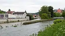
.jpg.webp) View from Kaulanger bridge in Kronach | |
| Location | |
| Country | Germany |
| State | Bayern |
| District | Upper Franconia |
| Reference no. | DE: 241446 |
| Physical characteristics | |
| Source | |
| • location | Source: Confluence of Kremnitz and Grümpel at Wilhelmsthal |
| • coordinates | 50°17′52″N 11°22′00″E |
| • elevation | 356 m above sea level (NN) |
| Mouth | |
• location | Confluence: in Kronach into Haßlach |
• coordinates | 50°14′13″N 11°19′14″E |
• elevation | ca. 305 m above sea level (NN) |
| Length | 7.94 km (4.93 mi) (with Kremnitz 27.6 km (17.1 mi)) [1] |
| Discharge | |
| • location | at Steinberg gauge[2] |
| • average | 1.7 m3/s (60 cu ft/s) |
| • minimum | Record low: 8 L/s (0.28 cu ft/s) Average low: 120 L/s (4.2 cu ft/s) |
| • maximum | Average high: 26.4 m3/s (930 cu ft/s) Record high: 58.4 m3/s (2,060 cu ft/s) (in 1947) |
| Basin features | |
| Progression | Haßlach→ Rodach→ Main→ Rhine→ North Sea |
 Confluence of Kronach (right) into the Haßlach (left) during the 2013 European floods | |
See also
References
- Complete table of the Bavarian Waterbody Register by the Bavarian State Office for the Environment (xls, 10.3 MB)
- Bayerischer Hochwassernachrichtendienst (as of 6. September 2011)
This article is issued from Wikipedia. The text is licensed under Creative Commons - Attribution - Sharealike. Additional terms may apply for the media files.