Ko Rang, Ko Chang
Ko Rang (Thai: เกาะรัง, pronounced [kɔ̀ʔ rāŋ]) is an island in the southwestern part of the Ko Chang archipelago on the southeastern edge of the Gulf of Thailand.[1] The island rises up out of 60m of water in most places and has few beaches.[2] The southeastern corner of the island offers a reasonable anchorage and the Thai Coast Guard has deployed several mooring buoys in this area for dive boats. There is a small Buddhist shrine on the beach adorned with phallic fertility statues. The small island of Ko Tun lies across a narrow channel to the south where fishing boats take shelter from the southwest monsoon.
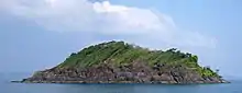
Small island next to Ko Rang.
References
Wikimedia Commons has media related to Ko Rang.
- "Koh Rang". Tourism Authority of Thailand (TAT). Archived from the original on 10 June 2015. Retrieved 10 June 2015.
- Cummings, Joe (2005). Thailand. Lonely Planet. pp. 264–265. ISBN 1-74059-697-8.
This article is issued from Wikipedia. The text is licensed under Creative Commons - Attribution - Sharealike. Additional terms may apply for the media files.