River Kinder
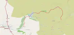
The River Kinder (/ˈkɪndər/ KIN-der) is a small river, only about 3 miles (4.8 km) long, in northwestern Derbyshire, England. Rising on the peat moorland plateau of Kinder Scout, it flows generally westwards to its confluence with the River Sett at Bowden Bridge (a Grade II listed packhorse bridge[1]). En route it flows through the Kinder Gates rocks, over the waterfall known as Kinder Downfall, and through Kinder Reservoir, built in 1903–12 by the Stockport Corporation Water Works. Until the 19th century at least, the name was formerly also applied to the River Sett as far as its confluence with the River Goyt in New Mills.[2]
| River Kinder | |
|---|---|
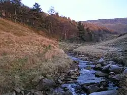
 The River Kinder above Kinder Reservoir | |
 The River Kinder is highlighted in red | |
| Location | |
| Country | England |
| Physical characteristics | |
| Source | |
| • location | Kinder Scout SK089881 |
| • coordinates | 53°23′22″N 1°52′04″W |
| • elevation | 636 m (2,087 ft) |
| Mouth | |
• location | River Sett SK050870 |
• coordinates | 53°22′48″N 1°55′35″W |
• elevation | 220 m (720 ft) |
| Length | 3 miles (4.8 km) |
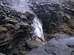
Kinder Downfall

Kinder Downfall is the tallest waterfall in the Peak District, with a 30-metre (98 ft) fall. The waterfall was formerly known as Kinder Scut, and it is from this that the plateau derives its name. Although usually little more than a trickle in summer, in spate conditions it is impressive. In certain wind conditions (notably when there is a strong west wind), the water is blown back on itself,[3] and the resulting cloud of spray can be seen from several miles away.[4] The Pennine Way crosses the River Kinder above Kinder Downfall.[5] When frozen in hard winters, the waterfall is a venue for ice-climbing,[6] and it is also the highlight of a fell race that bears its name.[7]
Kinder Reservoir

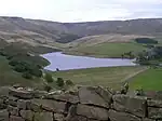
Stockport Corporation took over Stockport and District Waterworks Company in 1899 and immediately started investigating potential new water supplies. James Mansergh, consulting engineer, identified a site above Hayfield. Abram Kellett of Ealing was contracted to build a masonry dam and a standard gauge railway to convey materials and workers to the site (though some navvies and their families lived in temporary huts built a short distance down the valley). Two farms were demolished during the construction. Work started in 1903 but geological difficulties prompted suspension of construction in 1905 and eventually a change in design to a clay/earth dam. Stockport Corporation and the original contractor (Kelletts) resorted to the courts over financial issues and the Corporation's unilateral termination of the contract. Construction eventually resumed in 1908, under the supervision of G H Hill and Sons. The opening ceremony was held on 11 July 1912.[8] Kinder Reservoir has a capacity of approximately 2,289,000,000 litres (504,000,000 imp gal) and a surface area of 17.83 hectares (44.1 acres). The adjacent filter house was decommissioned in 1996, following the opening of the new Wybersley Water Treatment Works at High Lane, near Stockport, to which the reservoir's water is now piped for treatment.[9]
See also
References
- Historic England. "Old Packhorse Bridge (Grade II) (1088005)". National Heritage List for England. Retrieved 24 November 2017.
- Lewis, Samuel, ed. (1848). "A Topographical Dictionary of England". pp. 394–398. Retrieved 18 April 2018.
The Kinder derives its source from the mountain of Kinder-Scout, and, separating the county of Derby from that of Chester, falls into the river Guyt at a place called the Tor.
- Hooton, Christopher (22 October 2014). "It was so windy in Derbyshire yesterday a waterfall flowed uphill". The Independent. Retrieved 24 November 2017.
- Lewis, Steve. "Curiosities of Kinder Scout". stevelewis.me.uk. Retrieved 24 November 2017.
- OL1 Dark Peak area (Map). 1:25000. Explorer. Ordnance Survey.
- "Kinder Downfall". Rockfax. Retrieved 24 November 2017.
- "Kinder Downfall fell race route". Hand Picked Trails. Retrieved 24 November 2017.
- Brumhead, Derek; Rangeley, Jean; Rangeley, Ken (2008). The Kinder Reservoir and Railway. New Mills, Derbyshire: New Mills Heritage Centre.
- Kinder Reservoir Centenary 1912–2012 (onsite information board), National Trust/Peak District National Park Authority/Hayfield Civic Trust/United Utilities, 2012