Kern Valley Airport
Kern Valley Airport (FAA LID: L05) is a public airport located in the Kern River Valley, 3 miles (4.8 km) south of Kernville in Kern County, California, United States. It serves the Lake Isabella area in the Southern Sierra Nevada.
Kern Valley Airport | |||||||||||
|---|---|---|---|---|---|---|---|---|---|---|---|
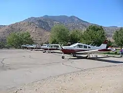 Mt SAC Flying Team annual practice at L05 | |||||||||||
| Summary | |||||||||||
| Airport type | Public | ||||||||||
| Operator | County of Kern | ||||||||||
| Location | Kernville, California | ||||||||||
| Elevation AMSL | 2,614 ft / 796.7 m | ||||||||||
| Coordinates | 35°43′42″N 118°25′11″W | ||||||||||
| Runways | |||||||||||
| |||||||||||
The airport is mostly used for general aviation.
Facilities
Kern Valley Airport covers 270 acres (109 ha) and has one runway:
- Runway 17/35: 3,500 by 50 feet (1,067 by 15 m), surface: asphalt
Use
The airport has an average of 28 operations per day.
| Commercial | Air taxi | GA local | GA transient | Military |
|---|---|---|---|---|
| 0 | 0 | 14 | 14 | 0 |
20 aircraft are based at the airport.
| Single engine | Multi engine | Jet | Helicopter | Glider/ultralight | Military |
|---|---|---|---|---|---|
| 20 | 0 | 0 | 0 | 0 | 0 |
References
External links
- Resources for this airport:
- FAA airport information for L05
- AirNav airport information for L05
- FlightAware airport information and live flight tracker
- SkyVector aeronautical chart for L05
This article is issued from Wikipedia. The text is licensed under Creative Commons - Attribution - Sharealike. Additional terms may apply for the media files.