Karioi railway station
Karioi was a station on the North Island Main Trunk line,[1] in the Ruapehu District of New Zealand.[2] A passing loop remains.[3]
Karioi railway station | |||||||||||
|---|---|---|---|---|---|---|---|---|---|---|---|
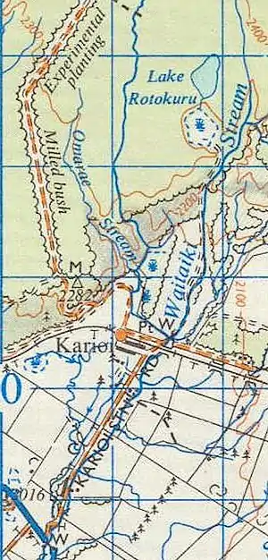
 Karioi railway station on 1966 map | |||||||||||
| General information | |||||||||||
| Location | New Zealand | ||||||||||
| Coordinates | 39.447576°S 175.512587°E | ||||||||||
| Elevation | 630 m (2,070 ft) | ||||||||||
| Line(s) | North Island Main Trunk | ||||||||||
| Distance | Wellington 307.14 km (190.85 mi) | ||||||||||
| History | |||||||||||
| Opened | 12 August 1907 | ||||||||||
| Closed | 23 June 1984 | ||||||||||
| Electrified | June 1988 | ||||||||||
| Previous names | Ninia | ||||||||||
| Services | |||||||||||
| |||||||||||

Name
The name was changed to Ninnia, or Ninia in 1907,[4] but reverted to Karioi in 1910,[5] though Ninia was still on the 1926 map.[6] Ninia was also later used, further north on the NIMT, at Waione Siding.[7] Karioi settlement lay 2 mi (3.2 km)[8] to the south[9] at what is now Karioi Domain.[10]
History
Surveying for the route between Hīhītahi and Piriaka began in 1894.[10] Bush felling for the railway started in 1900.[7] The rails were extended to the station in March,[11] or April 1907[12] and the line opened from Waiouru to Rangataua for goods traffic on 12 August 1907.[7]
A road to the station was built in 1907 for £1,078.10s. A 3rd class station was built by March 1908 with a budget of £7,672, though that may have included Ohakune. When opened Karioi had rooms for a stationmaster, luggage, urinals and ladies, on a 240 ft (73 m) by 15 ft (4.6 m) platform. There was also a 40 ft (12 m) by 30 ft (9.1 m) goods shed with verandah, a loading bank, cattle and sheep yards, two 4,000 imp gal (18,000 L) water tanks and a cart approach. There was a tablet and fixed signals. Cottages for railway staff were built from 1904 to 1919. A crossing loop could take 85 wagons. There was a Post Office at the station from 1913 to 1951. Approval to remove the station building was given in 1971. On 31 January 1982 the station closed to all traffic except in wagon lots and closed to that on 23 June1984.[7]
Mangawhero Sawmilling tramway
An agreement to log 3,700 acres (1,500 ha) was made in 1906.[13] Mangawhero Sawmilling Co's logging tramway ran east from the station between about 1922 and 1929.[2] About 1926 the mill bought 3 Nattrass Tractors[14] and were quoted as saying, "After spending £7000 on a tramway, and purchasing a locomotive (unable to shift any timber because of the grade being one in nine), one million and a half feet of timber accumulated, and your Rail Tractor saved the situation."[15] The line was worked by an NZR P class (1876) loco, transferred from the Sanson Tramway in about 1922, but it was dismantled by 1932.[16]

Lake Rotokura
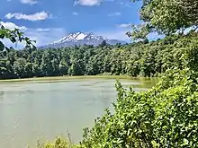
To the north of the station,[17] Lake Rotokura and Dry Lake are maar crater lakes.[18][19] A half hour walk from the station leads to the lake. It remains surrounded by beech forest, in which tūī, kākā, korimako, piwakawka and toutouwai are commonly seen.[20] Mistletoe is being monitored in the area.[21]
References
- Scoble, Juliet. "Names & Opening & Closing Dates of Railway Stations in New Zealand 1863 to 2010" (PDF). Rail Heritage Trust of New Zealand.
- New Zealand Railway and Tramway Atlas (Fourth ed.). Quail Map Co. 1993. ISBN 0-900609-92-3.
- "IntraMaps". maps.ruapehudc.govt.nz. Retrieved 7 November 2020.
- "LOCAL AND GENERAL. WANGANUI HERALD". paperspast.natlib.govt.nz. 8 July 1907. Retrieved 25 October 2020.
- "Appendix to the Journals of the House of Representatives 1910 Session – Inland Mail-services established, extended, etc". paperspast.natlib.govt.nz. Retrieved 25 October 2020.
- "Series: NZMS13 Sheet: WN22". www.mapspast.org.nz. 1926. Retrieved 25 October 2020.
- "Stations" (PDF). NZR Rolling Stock Lists. Retrieved 10 August 2020.
- "DEPARTMENT OF LANDS: SCENERY PRESERVATION. REPORT Appendix to the Journals of the House of Representatives". paperspast.natlib.govt.nz. 31 March 1907. Retrieved 25 October 2020.
- "DEPARTMENT OF LANDS: SCENERY PRESERVATION. REPORT Appendix to the Journals of the House of Representatives – map". paperspast.natlib.govt.nz. 31 March 1907. Retrieved 25 October 2020.
- "Karioi Domain, Manawatu-Wanganui". NZ Topo Map. Retrieved 5 November 2020.
- "MAIN TRUNK LINE. WAIRARAPA DAILY TIMES". paperspast.natlib.govt.nz. 19 March 1907. Retrieved 25 October 2020.
- "RAILWAY PROGRESS. HAWERA & NORMANBY STAR". paperspast.natlib.govt.nz. 13 April 1907. Retrieved 25 October 2020.
- "WELLINGTON TO AUCKLAND. NEW ZEALAND MAIL". paperspast.natlib.govt.nz. 11 April 1906. Retrieved 4 October 2020.
- "Nattrass Rail Tractors". www.trainweb.org. Retrieved 21 October 2020.
- LIGHT RAILWAYS OCTOBER, 1980 Nattrass Patented eight or twelve-wheel drive Rail Tractor
- "EARLY LOCOMOTIVES. AUCKLAND STAR". paperspast.natlib.govt.nz. 25 August 1932. Retrieved 25 October 2020.
- "Lake Rotokura, Manawatu-Wanganui". NZ Topo Map. Retrieved 26 October 2020.
- "'R'". www.geomarine.org.nz. Retrieved 26 October 2020.
- Hayward, Bruce W (July 2019). "The Campaign to Save Crater Hill Continues" (PDF).
- "Lake Rotokura Walk". www.doc.govt.nz. Retrieved 26 October 2020.
- "Tongariro Taupo Conservation Management Strategy 2002–2012" (PDF). DoC.