Ivory Island
Ivory Island Lightstation is located 14 miles northwest of Bella Bella[1] on the junction of Seaforth Channel and Milbanke Sound[2] on the Inside Passage of British Columbia.
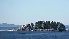
Ivory Island Lightstation
From 1937 to 1955, the Ivory Island lightstation was part of the British Columbia Shore Station Oceanographic Program, collecting coastal water temperature and salinity measurements for the Department of Fisheries and Oceans everyday for 18 years.[3]
Climate
Ivory Island has a wet and mild oceanic climate. (Cfb)
| Climate data for Ivory Island (1981–2010) | |||||||||||||
|---|---|---|---|---|---|---|---|---|---|---|---|---|---|
| Month | Jan | Feb | Mar | Apr | May | Jun | Jul | Aug | Sep | Oct | Nov | Dec | Year |
| Record high °C (°F) | 16.5 (61.7) |
15.5 (59.9) |
19.0 (66.2) |
25.5 (77.9) |
24.5 (76.1) |
33.0 (91.4) |
32.2 (90.0) |
29.0 (84.2) |
29.0 (84.2) |
22.0 (71.6) |
14.4 (57.9) |
15.5 (59.9) |
33.0 (91.4) |
| Average high °C (°F) | 6.2 (43.2) |
7.0 (44.6) |
8.0 (46.4) |
10.5 (50.9) |
12.5 (54.5) |
14.5 (58.1) |
16.2 (61.2) |
16.9 (62.4) |
15.3 (59.5) |
11.7 (53.1) |
8.3 (46.9) |
6.7 (44.1) |
11.1 (52.0) |
| Daily mean °C (°F) | 4.3 (39.7) |
4.9 (40.8) |
5.8 (42.4) |
8.0 (46.4) |
10.3 (50.5) |
12.6 (54.7) |
14.3 (57.7) |
14.9 (58.8) |
13.2 (55.8) |
9.8 (49.6) |
6.5 (43.7) |
4.9 (40.8) |
9.1 (48.4) |
| Average low °C (°F) | 2.5 (36.5) |
2.8 (37.0) |
3.4 (38.1) |
5.5 (41.9) |
8.1 (46.6) |
10.6 (51.1) |
12.4 (54.3) |
12.9 (55.2) |
11.0 (51.8) |
7.8 (46.0) |
4.6 (40.3) |
3.1 (37.6) |
7.0 (44.6) |
| Record low °C (°F) | −15.0 (5.0) |
−10.5 (13.1) |
−13.9 (7.0) |
−1.7 (28.9) |
0.0 (32.0) |
4.9 (40.8) |
6.1 (43.0) |
5.0 (41.0) |
2.2 (36.0) |
−1.0 (30.2) |
−12.0 (10.4) |
−12.5 (9.5) |
−15.0 (5.0) |
| Average precipitation mm (inches) | 297.6 (11.72) |
194.5 (7.66) |
229.5 (9.04) |
211.3 (8.32) |
147.0 (5.79) |
129.1 (5.08) |
118.1 (4.65) |
163.7 (6.44) |
215.2 (8.47) |
353.3 (13.91) |
383.7 (15.11) |
326.3 (12.85) |
2,769.2 (109.02) |
| Source: Environment Canada[4] | |||||||||||||
References
- "Ivory Island Lightstation". Archived from the original on 2011-07-19. Retrieved 2011-03-19.
- http://www.lighthousedepot.com/lite_explorer.asp?action=display_details&LighthouseID=1334
- "British Columbia Lightstation Sea-Surface Temperature and Salinity Data (Pacific), 1914-present - Open Government Portal". open.canada.ca. Treasury Board of Canada. Retrieved 2021-02-11.
- Environment Canada—. Retrieved September 5, 2017.
This article is issued from Wikipedia. The text is licensed under Creative Commons - Attribution - Sharealike. Additional terms may apply for the media files.