Indiana State Road 403
State Road 403 (SR 403), now known as County Road 403, is a six-mile (10 km) northeast-to-southwest route that lies entirely within Clark County.
State Road 403 | ||||
|---|---|---|---|---|
| County Road 403 | ||||
 | ||||
| Route information | ||||
| Maintained by INDOT | ||||
| Length | 5.54 mi[1] (8.92 km) | |||
| Existed | 1932–September 2012 | |||
| Major junctions | ||||
| South end | ||||
| North end | ||||
| Location | ||||
| Country | United States | |||
| State | Indiana | |||
| Counties | Clark | |||
| Highway system | ||||
| ||||
| ||||

Route description
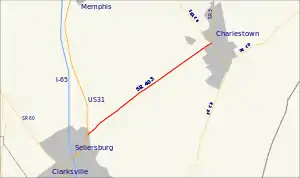
County Road 403 begins in the north end of Sellersburg at U.S. Route 31, just south of the community of Speed. The road runs northeast in a straight line toward central Charlestown where it intersects with State Road 160 at that road's eastern terminus. The road terminates at State Road 3 about 300 feet further to the northeast.
History
In September 2012, the entire length of SR 403 was decommissioned as a State Highway and taken over by Clark County.[2][3]
Major intersections
The entire route is in Clark County.
| Location | mi[1] | km | Destinations | Notes | |
|---|---|---|---|---|---|
| Sellersburg | 0.00 | 0.00 | Western terminus of SR 403 | ||
| Charlestown | 5.45 | 8.77 | Eastern terminus of SR 160 | ||
| 5.54 | 8.92 | Eastern terminus of SR 403 | |||
| 1.000 mi = 1.609 km; 1.000 km = 0.621 mi | |||||
References
- "INDOT Roadway Referencing System" (PDF). Archived from the original (PDF) on 2011-06-15.
- Chris McGill. "Clark County Takes Over Former State Roads". Archived from the original on November 8, 2012. Retrieved January 24, 2012.
- Clark County Highway Department
External links
Template:Attached KML/Indiana State Road 403
KML is from Wikidata
This article is issued from Wikipedia. The text is licensed under Creative Commons - Attribution - Sharealike. Additional terms may apply for the media files.