Hundred of Moule
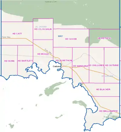
The Hundred of Moule is a cadastral hundred of South Australia[4] established in 1889 in the remote County of Way. Now bisected by the Eyre Highway, the traditional owners of the area are the Waringu people.
| Moule South Australia | |||||||||||||||
|---|---|---|---|---|---|---|---|---|---|---|---|---|---|---|---|
 The Hundred of Moule is located on the southern coast of the County of Way, South Australia | |||||||||||||||
 Moule | |||||||||||||||
| Coordinates | 32°01′58″S 133°32′03″E[1] | ||||||||||||||
| Established | 17 January 1889[2] | ||||||||||||||
| Area | 300 square kilometres (117 sq mi)[1] | ||||||||||||||
| LGA(s) | Ceduna[1] | ||||||||||||||
| Region | Eyre and Western[1] | ||||||||||||||
| County | Way | ||||||||||||||
| |||||||||||||||
| Footnotes | Adjoining Hundreds[3] | ||||||||||||||
References
- "Search results for 'Moule, HD' with the following datasets selected - 'Counties', 'Hundreds', 'Local Government Areas', 'SA Government Regions' and 'Gazetteer'". Location SA Map Viewer. Government of South Australian Government. Retrieved 4 August 2021.
- Ramsay, J.G. (17 January 1889). "untitled (proclamation of new county and hundreds)" (PDF). The South Australian Government Gazette. Government of South Australia. 1877: 95–96. Retrieved 4 August 2021.
- "HUNDRED MAP Series Index Map" (PDF). Department of Environment and Heritage, Government of South Australia. December 2008. Archived from the original (PDF) on 27 September 2015. Retrieved 16 November 2015.
- Vaughan, A.; Strawbridge, William (1910), McKenzie: Hundred of Moule, South Australia, A. Vaughan, photo-lithographer, retrieved 28 December 2018
This article is issued from Wikipedia. The text is licensed under Creative Commons - Attribution - Sharealike. Additional terms may apply for the media files.