Arkansas Highway 4
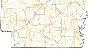
Highway 4 (AR 4, Ark. 4, and Hwy. 4) is a designation for two state highways in Arkansas. The western segment of 2.99 miles (4.81 km) runs from SH-4 at the Oklahoma state line and terminates in Cove.[2] An eastern segment of 22.49 miles (36.19 km) begins at U.S. Route 278 (US 278) in McGehee and heads east to Arkansas City then north to Highway 1 before terminating.[3] The two routes were formerly connected until a portion of approximately 230 miles (370 km) was redesignated US 278 in 1998. The eastern segment is part of the Great River Road.
Highway 4 | ||||
|---|---|---|---|---|
 | ||||
| Route information | ||||
| Maintained by ArDOT | ||||
| Existed | 1926–present | |||
| Section 1 | ||||
| Length | 2.99 mi[1] (4.81 km) | |||
| West end | ||||
| East end | ||||
| Section 2 | ||||
| Length | 22.49 mi[1] (36.19 km) | |||
| West end | ||||
| East end | ||||
| Location | ||||
| Country | United States | |||
| State | Arkansas | |||
| Highway system | ||||
| ||||
Route description
Oklahoma to Cove
The route enters Arkansas as Oklahoma State Highway 4 and runs east to Cove. The route then meets US 59/US 71 and ends.[2] AR 4 formerly continued along US 59/US 71 south to Wickes, then across the state along present US 278.
McGehee to Rowher

Highway 4 begins east of McGehee at US 65/US 165/US 278. The route winds east past the Delta Country Club and Trippe Holly Grove Cemetery before curving due east toward Arkansas City. The route runs east to Arkansas City. At Arkansas City, the route has its only spur route, which serves the historic part of town, while AR 4 turns north. The highway runs along the Mississippi River briefly before terminating at AR 1.[3]
Major intersections
| County | Location | mi[2] | km | Destinations | Notes | ||
|---|---|---|---|---|---|---|---|
| Polk | | 0.00 | 0.00 | Oklahoma state line | |||
| Cove | 2.99 | 4.81 | |||||
| Gap in route | |||||||
| Desha | McGehee | 0.0 | 0.0 | ||||
| 1.1 | 1.8 | ||||||
| 1.2 | 1.9 | ||||||
| Trippe Junction | 3.0 | 4.8 | |||||
| Arkansas City | 10.2 | 16.4 | |||||
| | 22.1 | 35.6 | |||||
| 1.000 mi = 1.609 km; 1.000 km = 0.621 mi | |||||||
Arkansas City spur
Highway 4S | |
|---|---|
| Location | Arkansas City |
| Length | 1.04 mi (1.67 km) |
Arkansas Highway 4S is a spur of 1.04 miles (1.67 km)[1] in Arkansas City.[3]
Former special routes
Camden business loop
Highway 4B | |
|---|---|
| Location | Camden |
| Length | 6.1 mi (9.8 km) |
| Existed | May 28, 1976[4]–1998 |
Highway 4B was a business route of 2.97 miles (4.78 km) in Camden; it was renamed U.S. 278B in the 1998 redesignation. The route began on Washington Street near the Camden Country Club and terminated at U.S. 79B.[5]
See also
References
- "[Arkansas] State Highways 2009 (Database)." April 2010. AHTD: Planning and Research Division. Database. Archived 2011-07-07 at the Wayback Machine Retrieved November 30, 2010.
- General Highway Map - Polk County, Arkansas (PDF) (Map) (10/18/00 ed.). Arkansas State Highway and Transportation Department. Retrieved March 12, 2011.
- General Highway Map - Desha County, Arkansas (PDF) (Map) (2/11/10 ed.). Arkansas State Highway and Transportation Department. Retrieved August 28, 2010.
- "Minutes of the Meeting" (PDF). Arkansas State Highway Commission. May 28, 1976. p. 653. Archived from the original (PDF) on November 5, 2011. Retrieved January 28, 2013.
- "Camden, Arkansas." Arkansas State Highway and Transportation Department. AHTD Camden, Arkansas map. Retrieved on August 28, 2010.
External links
![]() Media related to Arkansas Highway 4 at Wikimedia Commons
Media related to Arkansas Highway 4 at Wikimedia Commons
