Godley, Texas
Godley is a city in northwestern Johnson County, Texas, United States, in the Dallas–Fort Worth metroplex. It is on Texas State Highway 171, Farm Roads 2331 and 917, and the tracks of the Atchison, Topeka and Santa Fe Railway northwest of Cleburne. The population was 1,009 in 2010,[5] up from 879 in 2000.
Godley, Texas | |
|---|---|
Downtown Godley (2022) | |
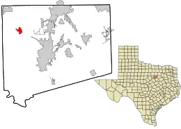
 Location in Johnson County and the state of Texas | |
| Coordinates: 32°26′54″N 97°31′46″W | |
| Country | United States |
| State | Texas |
| County | Johnson |
| Government | |
| • Mayor | Acy McGehee |
| Area | |
| • Total | 2.20 sq mi (5.69 km2) |
| • Land | 2.18 sq mi (5.65 km2) |
| • Water | 0.01 sq mi (0.04 km2) |
| Elevation | 928 ft (283 m) |
| Population (2010) | |
| • Total | 1,009 |
| • Estimate (2019)[2] | 1,373 |
| • Density | 629.24/sq mi (242.93/km2) |
| Time zone | UTC-6 (Central (CST)) |
| • Summer (DST) | UTC-5 (CDT) |
| ZIP code | 76044 |
| Area code | 817 |
| FIPS code | 48-29972[3] |
| GNIS feature ID | 1336634[4] |
| Website | godleytx |
History
Godley was established in 1886 and named for R. B. Godley, a Cleburne lumber merchant who donated an 8-acre (3.2 ha) tract for a townsite and 20 acres (8.1 ha) of land as a right-of-way to the Gulf, Colorado and Santa Fe Railway. A station was constructed in 1886. By 1888, when the post office opened, Godley had a gristmill, three cotton gins, and two dairy-processing plants. Four years later it had two general stores. By the mid-1920s, the population was 613. In 1930 it was 378, and twenty-two rated businesses operated locally. In the 1940s, the town had a population of 317 and twenty businesses. By 1956, it had a population of 424 and sixteen businesses, and by 1990 it had 569 people and twelve businesses.[6]
Geography
Godley is located at 32°26′54″N 97°31′46″W (32.448427, –97.529520).[7] Via Highway 171 it is 11 miles (18 km) northwest of Cleburne, the Johnson county seat, and 8 miles (13 km) southeast of Cresson. It is 30 miles (48 km) southwest of downtown Fort Worth.
According to the United States Census Bureau, Godley has a total area of 1.7 square miles (4.3 km2), of which 0.01 square miles (0.02 km2), or 0.39%, are water.[5] It lies near the headwaters of the Nolan River watershed, a tributary of the Brazos River.
Demographics
| Census | Pop. | Note | %± |
|---|---|---|---|
| 1930 | 378 | — | |
| 1940 | 317 | −16.1% | |
| 1950 | 424 | 33.8% | |
| 1960 | 401 | −5.4% | |
| 1970 | 533 | 32.9% | |
| 1980 | 614 | 15.2% | |
| 1990 | 569 | −7.3% | |
| 2000 | 879 | 54.5% | |
| 2010 | 1,009 | 14.8% | |
| 2019 (est.) | 1,373 | [2] | 36.1% |
| U.S. Decennial Census[8] | |||
As of the census[3] of 2000, there were 879 people, 296 households, and 235 families residing in the city. The population density was 523.7 inhabitants per square mile (202.2/km2). There were 313 housing units at an average density of 186.5 per square mile (72.0/km2). The racial makeup of the city was 94.43% White, 0.46% African American, 0.80% Native American, 2.73% from other races, and 1.59% from two or more races. Hispanic or Latino of any race were 10.13% of the population.
There were 296 households, out of which 45.3% had children under the age of 18 living with them, 61.1% were married couples living together, 13.2% had a female householder with no husband present, and 20.3% were non-families. 17.6% of all households were made up of individuals, and 8.8% had someone living alone who was 65 years of age or older. The average household size was 2.95 and the average family size was 3.34.
In the city, the population was spread out, with 32.5% under the age of 18, 9.1% from 18 to 24, 28.7% from 25 to 44, 20.4% from 45 to 64, and 9.3% who were 65 years of age or older. The median age was 31 years. For every 100 females, there were 84.7 males. For every 100 females age 18 and over, there were 88.3 males.
The median income for a household in the city was $40,667, and the median income for a family was $44,583. Males had a median income of $37,692 versus $23,571 for females. The per capita income for the city was $14,556. About 5.2% of families and 7.7% of the population were below the poverty line, including 6.9% of those under age 18 and 6.6% of those age 65 or over.
Education
Public education in the city is provided by the Godley Independent School District.
References
- "2019 U.S. Gazetteer Files". United States Census Bureau. Retrieved August 7, 2020.
- "Population and Housing Unit Estimates". United States Census Bureau. May 24, 2020. Retrieved May 27, 2020.
- "U.S. Census website". United States Census Bureau. Retrieved January 31, 2008.
- "US Board on Geographic Names". United States Geological Survey. October 25, 2007. Retrieved January 31, 2008.
- "Geographic Identifiers: 2010 Census Summary File 1 (G001): Godley city, Texas". American Factfinder. U.S. Census Bureau. Archived from the original on February 13, 2020. Retrieved December 21, 2018.
- GODLEY, TX, Handbook of Texas Online. Accessed January 27, 2010.
- "US Gazetteer files: 2010, 2000, and 1990". United States Census Bureau. February 12, 2011. Retrieved April 23, 2011.
- "Census of Population and Housing". Census.gov. Retrieved June 4, 2015.
