Giannutri Lighthouse
Giannutri Lighthouse (Italian: Faro di Giannutri) is an active lighthouse, located at Punta Rossa, the southernmost part of the island and of the Tuscan Archipelago on the Tyrrhenian Sea.
 Giannutri Lighthouse | |
| Location | Giannutri Tuscany Italy |
|---|---|
| Coordinates | 42°14′22″N 11°06′29″E |
| Tower | |
| Constructed | 1882 |
| Foundation | concrete base |
| Construction | masonry tower |
| Automated | yes |
| Height | 9 metres (30 ft) |
| Shape | cylindrical tower with balcony and lantern attached to the front side of one-storey keeper's house |
| Markings | tower and building painted in red and white stripes, grey metallic lantern dome |
| Power source | solar power |
| Operator | Marina Militare[1][2] |
| Fog signal | no |
| Light | |
| Focal height | 61 metres (200 ft) |
| Lens | Type OF |
| Intensity | LABI 100 w |
| Range | main: 13 nautical miles (24 km; 15 mi) |
| Characteristic | Fl W 5s. |
| Italy no. | 2184 E.F |
Description
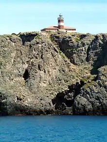
The lighthouse, built in 1882, consists of a masonry cylindrical tower, 9 metres (30 ft) high attached to the front side of a one-storey keeper's house, painted with red and white horizontal bands.
The light is positioned at 61 metres (200 ft) above sea level and emits one white flash in a 5 seconds period, visible up to a distance of 13 nautical miles (24 km; 15 mi). The lighthouse is completely automated, powered by a solar unit, and managed by the Marina Militare with the identification code number 2184 E.F.[2]
See also
References
- Rowlett, Russ. "Lighthouses of Italy: Tuscany". The Lighthouse Directory. University of North Carolina at Chapel Hill. Retrieved August 19, 2018.
- "Isola di Giannutri". Marina Militare. Retrieved August 19, 2018.
External links
Wikimedia Commons has media related to Giannutri lighthouse.
This article is issued from Wikipedia. The text is licensed under Creative Commons - Attribution - Sharealike. Additional terms may apply for the media files.