Garcia Hernandez
Garcia Hernandez, officially the Municipality of Garcia Hernandez (Cebuano: Munisipalidad sa Garcia Hernandez; Tagalog: Bayan ng Garcia Hernandez), is a 4th class municipality in the province of Bohol, Philippines. According to the 2020 census, it has a population of 24,430 people.[4]
Garcia Hernandez | |
|---|---|
| Municipality of Garcia Hernandez | |
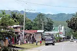
 Garcia Hernandez – public market | |
 Flag  Seal | |
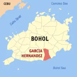
 Map of Bohol with Garcia Hernandez highlighted | |
OpenStreetMap | |
.svg.png.webp) Garcia Hernandez Location within the Philippines | |
| Coordinates: 9°36′52″N 124°17′41″E | |
| Country | Philippines |
| Region | Central Visayas |
| Province | Bohol |
| District | 3rd district |
| Barangays | 30 (see Barangays) |
| Government | |
| • Type | Sangguniang Bayan |
| • Mayor | Engr. Filadelfo III Jess V.Baja |
| • Vice Mayor | Antonia J. Ladaga |
| • Representative | Kristine Alexie B. Tutor |
| • Municipal Council | Members |
| • Electorate | 18,085 voters (2022) |
| Area | |
| • Total | 127.50 km2 (49.23 sq mi) |
| Elevation | 2.0 m (6.6 ft) |
| Population (2020 census)[4] | |
| • Total | 24,430 |
| • Density | 190/km2 (500/sq mi) |
| • Households | 5,448 |
| Economy | |
| • Income class | 4th municipal income class |
| • Poverty incidence | 17.60 |
| • Revenue | ₱ 121.4 million (2020) |
| • Assets | ₱ 260.5 million (2020) |
| • Expenditure | ₱ 100.3 million (2020) |
| • Liabilities | ₱ 38.42 million (2020) |
| Service provider | |
| • Electricity | Bohol 2 Electric Cooperative (BOHECO 2) |
| Time zone | UTC+8 (PST) |
| ZIP code | 6307 |
| PSGC | |
| IDD : area code | +63 (0)38 |
| Native languages | Boholano dialect Cebuano Tagalog |
| Website | garciahernandez |
The town is home to the sacred burial cave of Kalagan.[6]
Geography
Barangays
Garcia Hernandez is politically subdivided into 30 barangays. Each barangay consists of puroks and some have sitios.
| PSGC | Barangay | Population | ±% p.a. | Area | PD 2020 | |||||
|---|---|---|---|---|---|---|---|---|---|---|
| 2020[4] | 2010[7] | ha | acre | /km2 | /sq mi | |||||
| 071222001 | Abijilan | 5.8% | 1,411 | 1,479 | −0.47% | 820 | 2,026 | 170 | 450 | |
| 071222002 | Antipolo | 2.5% | 613 | 627 | −0.23% | 522 | 1,290 | 120 | 300 | |
| 071222003 | Basiao | 2.2% | 532 | 514 | 0.34% | 236 | 583 | 230 | 580 | |
| 071222004 | Cagwang | 1.4% | 351 | 340 | 0.32% | 532 | 1,315 | 66 | 170 | |
| 071222005 | Calma | 3.1% | 759 | 752 | 0.09% | 126 | 311 | 600 | 1,600 | |
| 071222006 | Cambuyo | 2.6% | 638 | 614 | 0.38% | 642 | 1,586 | 99 | 260 | |
| 071222007 | Canayaon East | 3.8% | 925 | 931 | −0.06% | 211 | 521 | 440 | 1,100 | |
| 071222008 | Canayaon West | 4.0% | 965 | 945 | 0.21% | 194 | 479 | 500 | 1,300 | |
| 071222009 | Candanas | 3.1% | 765 | 771 | −0.08% | 735 | 1,816 | 100 | 270 | |
| 071222010 | Candulao | 1.9% | 459 | 422 | 0.84% | 132 | 326 | 350 | 900 | |
| 071222011 | Catmon | 1.1% | 277 | 220 | 2.33% | 240 | 593 | 120 | 300 | |
| 071222012 | Cayam | 4.7% | 1,140 | 1,194 | −0.46% | 541 | 1,337 | 210 | 550 | |
| 071222013 | Cupa | 0.9% | 218 | 212 | 0.28% | 245 | 605 | 89 | 230 | |
| 071222014 | Datag | 5.2% | 1,268 | 1,184 | 0.69% | 1,289 | 3,185 | 98 | 250 | |
| 071222015 | Estaca | 0.8% | 203 | 194 | 0.45% | 194 | 479 | 100 | 270 | |
| 071222016 | Libertad | 1.8% | 436 | 421 | 0.35% | 380 | 939 | 110 | 300 | |
| 071222017 | Lungsodaan East | 4.6% | 1,114 | 1,098 | 0.14% | 718 | 1,774 | 160 | 400 | |
| 071222018 | Lungsodaan West | 4.5% | 1,105 | 997 | 1.03% | 637 | 1,574 | 170 | 450 | |
| 071222019 | Malinao | 5.5% | 1,338 | 1,046 | 2.49% | 634 | 1,567 | 210 | 550 | |
| 071222020 | Manaba | 7.1% | 1,723 | 1,679 | 0.26% | 296 | 731 | 580 | 1,500 | |
| 071222021 | Pasong | 4.5% | 1,101 | 918 | 1.83% | 684 | 1,690 | 160 | 420 | |
| 071222022 | Poblacion East | 5.6% | 1,370 | 1,328 | 0.31% | 439 | 1,085 | 310 | 810 | |
| 071222023 | Poblacion West | 3.7% | 906 | 961 | −0.59% | 422 | 1,043 | 210 | 560 | |
| 071222024 | Sacaon | 2.6% | 629 | 614 | 0.24% | 253 | 625 | 250 | 640 | |
| 071222025 | Sampong | 1.0% | 243 | 241 | 0.08% | 524 | 1,295 | 46 | 120 | |
| 071222026 | Tabuan | 5.4% | 1,318 | 1,277 | 0.32% | 750 | 1,853 | 180 | 460 | |
| 071222027 | Togbongon | 1.3% | 324 | 367 | −1.24% | 388 | 959 | 84 | 220 | |
| 071222028 | Ulbujan East | 2.8% | 690 | 673 | 0.25% | 419 | 1,035 | 160 | 430 | |
| 071222029 | Ulbujan West | 3.4% | 831 | 745 | 1.10% | 426 | 1,053 | 200 | 510 | |
| 071222030 | Victoria | 1.1% | 272 | 274 | −0.07% | 118 | 292 | 230 | 600 | |
| Total | 24,430 | 23,038 | 0.59% | 12,750 | 31,506 | 190 | 500 | |||
Climate
| Climate data for Garcia Hernandez, Bohol | |||||||||||||
|---|---|---|---|---|---|---|---|---|---|---|---|---|---|
| Month | Jan | Feb | Mar | Apr | May | Jun | Jul | Aug | Sep | Oct | Nov | Dec | Year |
| Average high °C (°F) | 28 (82) |
29 (84) |
30 (86) |
31 (88) |
31 (88) |
30 (86) |
30 (86) |
30 (86) |
30 (86) |
29 (84) |
29 (84) |
29 (84) |
30 (85) |
| Average low °C (°F) | 23 (73) |
22 (72) |
23 (73) |
23 (73) |
24 (75) |
25 (77) |
24 (75) |
24 (75) |
24 (75) |
24 (75) |
23 (73) |
23 (73) |
24 (74) |
| Average precipitation mm (inches) | 102 (4.0) |
85 (3.3) |
91 (3.6) |
75 (3.0) |
110 (4.3) |
141 (5.6) |
121 (4.8) |
107 (4.2) |
111 (4.4) |
144 (5.7) |
169 (6.7) |
139 (5.5) |
1,395 (55.1) |
| Average rainy days | 18.6 | 14.8 | 16.5 | 16.7 | 23.9 | 26.4 | 25.6 | 24.1 | 24.4 | 26.3 | 23.7 | 20.5 | 261.5 |
| Source: Meteoblue[8] | |||||||||||||
Demographics
| Year | Pop. | ±% p.a. |
|---|---|---|
| 1903 | 6,060 | — |
| 1918 | 8,555 | +2.33% |
| 1939 | 11,486 | +1.41% |
| 1948 | 13,690 | +1.97% |
| 1960 | 12,828 | −0.54% |
| 1970 | 13,604 | +0.59% |
| 1975 | 16,701 | +4.20% |
| 1980 | 16,715 | +0.02% |
| 1990 | 18,956 | +1.27% |
| 1995 | 21,323 | +2.23% |
| 2000 | 21,428 | +0.11% |
| 2007 | 21,308 | −0.08% |
| 2010 | 23,038 | +2.88% |
| 2015 | 24,194 | +0.94% |
| 2020 | 24,430 | +0.19% |
| Source: Philippine Statistics Authority[9][7][10][11] | ||
Economy
Poverty Incidence of Garcia Hernandez
Parishes
- Saint John the Baptist
- Saint Isidore the Farmer
Gallery
 Municipal hall
 Roman Catholic Church
References
- Municipality of Garcia Hernandez | (DILG)
- "2015 Census of Population, Report No. 3 – Population, Land Area, and Population Density" (PDF). Philippine Statistics Authority. Quezon City, Philippines. August 2016. ISSN 0117-1453. Archived (PDF) from the original on May 25, 2021. Retrieved July 16, 2021.
- Error: Unable to display the reference properly. See the documentation for details.
- Census of Population (2020). "Region VII (Central Visayas)". Total Population by Province, City, Municipality and Barangay. Philippine Statistics Authority. Retrieved 8 July 2021.
- "PSA Releases the 2018 Municipal and City Level Poverty Estimates". Philippine Statistics Authority. 15 December 2021. Retrieved 22 January 2022.
- ""KALAGAN" Ancient Burial Cave". YouTube. Archived from the original on 2021-12-05.
- Census of Population and Housing (2010). "Region VII (Central Visayas)" (PDF). Total Population by Province, City, Municipality and Barangay. National Statistics Office. Retrieved 29 June 2016.
- "Garcia Hernandez: Average Temperatures and Rainfall". Meteoblue. Retrieved 9 May 2020.
- Census of Population (2015). "Region VII (Central Visayas)". Total Population by Province, City, Municipality and Barangay. Philippine Statistics Authority. Retrieved 20 June 2016.
- Censuses of Population (1903–2007). "Region VII (Central Visayas)". Table 1. Population Enumerated in Various Censuses by Province/Highly Urbanized City: 1903 to 2007. National Statistics Office.
- "Province of Bohol". Municipality Population Data. Local Water Utilities Administration Research Division. Retrieved 17 December 2016.
- "Poverty incidence (PI):". Philippine Statistics Authority. Retrieved December 28, 2020.
- "Estimation of Local Poverty in the Philippines" (PDF). Philippine Statistics Authority. 29 November 2005.
- "2003 City and Municipal Level Poverty Estimates" (PDF). Philippine Statistics Authority. 23 March 2009.
- "City and Municipal Level Poverty Estimates; 2006 and 2009" (PDF). Philippine Statistics Authority. 3 August 2012.
- "2012 Municipal and City Level Poverty Estimates" (PDF). Philippine Statistics Authority. 31 May 2016.
- "Municipal and City Level Small Area Poverty Estimates; 2009, 2012 and 2015". Philippine Statistics Authority. 10 July 2019.
- "PSA Releases the 2018 Municipal and City Level Poverty Estimates". Philippine Statistics Authority. 15 December 2021. Retrieved 22 January 2022.
This article is issued from Wikipedia. The text is licensed under Creative Commons - Attribution - Sharealike. Additional terms may apply for the media files.