Foel-goch
Foel-goch is a mountain in Snowdonia, north-west Wales, and forms part of the Glyderau range, in Gwynedd. It lies in between Y Garn and Mynydd Perfedd.[1]
| Foel-goch | |
|---|---|
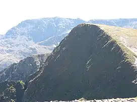 Foel-goch from Mynydd Perfedd | |
| Highest point | |
| Elevation | 831 m (2,726 ft) |
| Prominence | 76 m (249 ft) |
| Parent peak | Y Garn |
| Listing | Hewitt, Nuttall |
| Coordinates | 53.130372°N 4.051322°W |
| Geography | |
| Location | Gwynedd, Wales |
| Parent range | Snowdonia |
| Topo map | OS Landranger 115 |
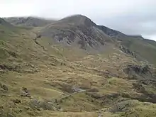
Foel-goch from Nant Ffrancon pass
Good views of Dyffryn Ogwen are seen with Pen yr Ole Wen, Carnedd Dafydd, Tryfan, Glyder Fawr and Elidir Fawr close by. Its height is 831 metres (2,726 ft).[2]
References
- Nuttall, John & Anne (1999). The Mountains of England & Wales - Volume 1: Wales (2nd edition ed.). Milnthorpe, Cumbria: Cicerone. ISBN 1-85284-304-7.
- Crocker, Chris; Graham Jackson. "Mountaineering & Rock Climbing in the UK: Foel Goch". Database of British Hills. Mountain Days.net. Archived from the original on 19 July 2011. Retrieved 8 April 2008.
This article is issued from Wikipedia. The text is licensed under Creative Commons - Attribution - Sharealike. Additional terms may apply for the media files.