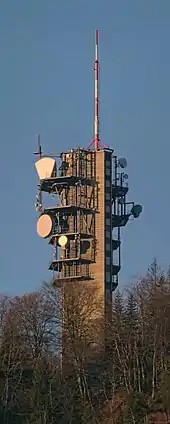
Felsenegg-Girstel TV-tower
The Felsenegg Tower is a broadcasting tower located nearby Felseneggbahn mountain station on the Felsenegg vantage point in the canton of Zürich in Switzerland. The tower is owned by Swisscom Broadcast AG and generally not accessible by the public.


History
The Felsenegg Tower was built between 1959 and 1963 by architect Edwin Schoch from Zurich. Originally, it was designed for telephone transmission and broadcasting of radio and television programs.[1] It was officially called Albis (abbreviated ALBS) by PTT (Swiss Telecom PTT, now Swisscom)[2]
The tower was the number one national and international (Eurovision) technical control centre for TV transmissions and later, it was the connection point of many private TV stations in Switzerland allowing to connect to the national and international TV net. The REAL system switches antennas on other 27 Swisscom-towers. Today, Felsenegg is becoming less important, as the optical fiber technology will replace microwave radio technology. Felsenegg still supplies directional radio but also FM broadcasting among them Radio Zürisee in Rapperswil. Since 2005, Skyguide maintains a radar station at the same location.[3]
Technical data
The tower has a triangular form with cut edges, is 51 metres (167 ft) high and has a 22 metres (72 ft) high pole on its top. It has 16 floors and an underground building for technical equipment. The antennas are on the terraces of the 5 top floors and on the roof. For its directional radio system there are parabolic antennas, horn and shell antennas. The power for directional radio is quite small in comparison to the Uetliberg TV-tower: 10W at the maximum for a connection from Felsenegg to Chasseral of about 110 kilometres (68 mi).[3]
References
- Die Tat 28.11.2960 / private archive
- Archiv PTT
- "ETH Zürich, Guido Hungerbühler and Oliver Knecht: Introduction to the Uetliberg and Felsenegg tower" (PDF). Archived from the original (PDF) on 2011-07-06. Retrieved 2009-12-09. (1340 KB)