Far Eastern Federal District
The Far Eastern Federal District (Russian: Дальневосто́чный федера́льный о́круг) is the largest of the eight federal districts of Russia but least populated, with a population of around 8 million (73.6% urban) according to the 2021 Census. The federal district lies entirely within the easternmost part of Asia and is coextensive with the Russian Far East.
Far Eastern Federal District
Дальневосточный федеральный округ | |
|---|---|
.svg.png.webp) Location of the Far Eastern Federal District | |
| Country | |
| Established | 18 May 2000 |
| Administrative center | Vladivostok |
| Government | |
| • Presidential Envoy | Yury Trutnev |
| Area | |
| • Total | 6,952,600 km2 (2,684,400 sq mi) |
| • Rank | 1st of 8 (40.6% of the country) |
| Population (2021[2]) | |
| • Total | 7,975,762 |
| • Rank | 8th of 8 (5.6% of the country) |
| • Density | 1.1/km2 (3.0/sq mi) |
| • Urban | 73.6% |
| • Rural | 26.4% |
| Time zones | |
| Buryatia | UTC+08:00 (Irkutsk Time) |
| Amur Oblast, Zabaykalsky Krai and most of the Sakha Republic (excluding districts in UTC+10:00 and UTC+11:00 time zones) | UTC+09:00 (Yakutsk Time) |
| Jewish Autonomous Oblast, Khabarovsk Krai, Primorsky Krai, and the Oymyakonsky, Ust-Yansky and Verkhoyansky districts of the Sakha Republic | UTC+10:00 (Vladivostok Time) |
| Magadan Oblast, Sakhalin Oblast, and the Abyysky, Allaikhovsky, Momsky, Nizhnekolymsky, Srednekolymsky and Verkhnekolymsky districts of the Sakha Republic | UTC+11:00 (Magadan Time) |
| Chukotka and Kamchatka Krai | UTC+12:00 (Kamchatka Time) |
| Federal subjects | 11 contained |
| Economic regions | 1 contained |
| HDI (2021) | 0.808[3] very high · 4th |
| Website | DFO.gov.ru |
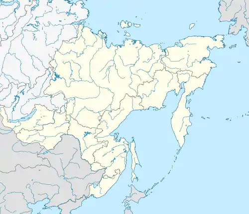
.jpg.webp)
History
The Far Eastern Federal District was established on 18 May 2000, by President Vladimir Putin and is currently being governed by presidential envoy Yury Trutnev. In November 2018, Buryatia and Zabaykalsky Krai were added to the federal district.[4] The seat of the Far Eastern Federal District was moved from Khabarovsk to Vladivostok in December 2018.[5]
On 15 July 2022, the first high-speed highway was opened in the Far Eastern Federal District. It united three federal highways – Ussuri (Khabarovsk–Vladivostok), Amur (Chita–Khabarovsk) and Vostok (Khabarovsk–Nakhodka), and connect the regional capital with Komsomolsk-on-Amur, as well as sites of the territory of the advancing socio-economic development (SAD).[6]
Demographics
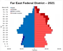
Federal subjects
.svg.png.webp) | |||||||
|---|---|---|---|---|---|---|---|
| # | Flag | Coat of Arms | Federal subject | Area in km2[1] |
Population (2021 census) |
Capital/Administrative center | Map of Administrative Division |
| 1 |  |
Amur Oblast | 361,900 | 766,912 | Blagoveshchensk | ||
| 2 |  |
Republic of Buryatia | 351,300 | 978,588 | Ulan-Ude | ||
| 3 |  |
Jewish Autonomous Oblast | 36,300 | 150,453 | Birobidzhan | ||
| 4 |  |
Zabaykalsky Krai | 431,900 | 1,004,125 | Chita |  | |
| 5 |  |
Kamchatka Krai | 464,300 | 291,705 | Petropavlovsk-Kamchatsky |  | |
| 6 |  |
Magadan Oblast | 462,500 | 136,085 | Magadan | ||
| 7 |  |
Primorsky Krai | 164,700 | 1,845,165 | Vladivostok | ||
| 8 | .svg.png.webp) |
Sakha Republic | 3,083,500 | 995,686 | Yakutsk | ||
| 9 |  |
Sakhalin Oblast | 87,100 | 466,609 | Yuzhno-Sakhalinsk |  | |
| 10 |  |
Khabarovsk Krai | 787,600 | 1,292,944 | Khabarovsk | 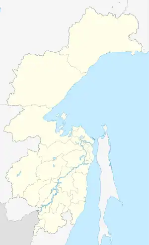 | |
| 11 |  |
Chukotka Autonomous Okrug | 721,500 | 47,490 | Anadyr | ||

Largest cities with a population over 75,000
There are 82 cities in the Far Eastern Federal District, and 13 cities have populations over 75,000.
Only four of these 13 cities (Komsomolsk-on-Amur (7th) in Khabarovsk Krai, Ussuriysk (9th), Nakhodka (11th), Artyom (12th) in Primorsky Krai) are not administrative centres of a federal subject. Anadyr, the centre of Chukotka Autonomous Okrug, is one of the smallest centres of a federal subject (it has only 13,045 inhabitants). Only Magas, the centre of Ingushetia, is smaller than Anadyr.
Artyom is a large suburb of the Vladivostok metropolitan area.[7]
Populations are given as of the 2021 census:
- Khabarovsk: 617,441
- Vladivostok: 603,519
- Ulan-Ude: 437,565
- Yakutsk: 355,443
- Chita: 334,427
- Blagoveshchensk: 241,437
- Komsomolsk-on-Amur: 238,505
- Yuzhno-Sakhalinsk: 181,587
- Ussuriysk: 180,393
- Petropavlovsk-Kamchatsky: 164,900
- Nakhodka: 139,931
- Artyom: 109,556
- Magadan: 90,757
Religion
According to a 2012 survey[8] 27.4% of the population of the current federal subjects of the Far Eastern Federal District (including Buryatia and Zabaykalsky Krai) adheres to the Russian Orthodox Church, 5.0% are unaffiliated generic Christians, 1.4% is an Orthodox believer without belonging to any church or adheres to other (non-Russian) Orthodox churches, 3.3% is an adherent of Buddhism, 0.7% is an adherent of Islam, and 2.2% adhere to some native faith such as Rodnovery, Tengrism, Yellow shamanism, or Black shamanism. In addition, 27.0% of the population declares to be "spiritual but not religious", 23.5% is atheist, and 9.5% follows other religions or did not give an answer to the question.[8]
Ethnicity

The ethnic composition, according to the 2021 census (after the integration of Buryatia and Zabaykalsky Krai in 2018) was:
- Total – 6,979,578 people
- Russians – 5,674,671 (81.30%)
- Yakuts – 472,116 (6.76%)
- Buryats – 371,677 (5.33%)
- Ukrainians – 47,560 (0.68%)
- Evenki – 33,760 (0.48%)
- Koreans – 29,855 (0.43%)
- Tatars – 24,605 (0.35%)
- Uzbeks – 23,477 (0.34%)
- Armenians – 20,185 (0.29%)
- Kyrgyz – 19,659 (0.28%)
- Evens (Lamuts) – 19,561 (0.28%)
- Tajiks – 17,812 (0.26%)
- Chukchi – 15,686 (0.22%)
- Azerbaijanis – 13,011 (0.19%)
- Nanai – 11,424 (0.16%)
- Chinese – 8,396 (0.12%)
- Belarusians – 7,944 (0.11%)
- Koryaks – 7,292 (0.10%)
- Kazakhs – 4,614 (0.07%)
- Bashkirs – 4,391 (0.06%)
- Nivkh – 3,758 (0.05%)
- Germans – 3,564 (0.05%)
- Chuvash – 2,906 (0.04%)
- Moldovans – 2,851 (0.04%)
- Mordva – 2,675 (0.04%)
- Jews – 2,529 (0.04%)
- Ulchi – 2,431 (0.03%)
- Yukaghir – 1,747 (0.03%)
- Itelmens – 1,486 (0.02%)
- Mari – 1,230 (0.02%)
- Individuals who did not indicate nationality – 996,184 (12.49%)
Presidential plenipotentiary envoys
- Konstantin Pulikovsky (18 May 2000 – 14 November 2005)
- Kamil Iskhakov (14 November 2005 – 2 October 2007)
- Oleg Safonov (30 November 2007 – 30 April 2009)
- Viktor Ishayev (30 April 2009 – 30 August 2013)
- Yury P. Trutnev (31 August 2013 – present)
See also
References
- "1.1. ОСНОВНЫЕ СОЦИАЛЬНО-ЭКОНОМИЧЕСКИЕ ПОКАЗАТЕЛИ в 2014 г." [MAIN SOCIOECONOMIC INDICATORS 2014]. Regions of Russia. Socioeconomic indicators – 2015 (in Russian). Russian Federal State Statistics Service. Retrieved 26 July 2016.
- "Provisional results of the 2020 All-Russian population census" (in Russian). Rosstat. 30 May 2022. Retrieved 30 May 2022.
- "Sub-national HDI – Area Database – Global Data Lab". hdi.globaldatalab.org. Retrieved 20 July 2021.
- "Официальный интернет-портал правовой информации". publication.pravo.gov.ru. Retrieved 4 November 2018.
- "Путин перенес столицу Дальневосточного федерального округа во Владивосток". meduza.io. Retrieved 13 December 2018.
- "Доев Дмитрий: "Обход Хабаровска" – флагман дорожных концессий Группы "ВИС"". PRIMPRESS.RU (in Russian). Retrieved 30 March 2023.
- Подписано соглашение о создании Владивостокской агломерации (in Russian)
- "Arena: Atlas of Religions and Nationalities in Russia". Sreda, 2012.
- 2012 Arena Atlas Religion Maps. "Ogonek", № 34 (5243), 27 August 2012. Retrieved 21 April 2017. Archived.
External links
- Meeting of Frontiers: Siberia, Alaska, and the American West (includes materials on the Russian Far East) (in English and Russian)
- Unofficial website of the Far Eastern Federal District (in Russian)