Safe water mark
A safe water mark, as defined by the International Association of Lighthouse Authorities, is a sea mark used in maritime pilotage to indicate the end of a channel. They usually imply that open, deep and safe water lies ahead. They are also used to indicate the start and end of a buoyed section of a continuous narrow channel; and a series of them may mark a safe route through shallow areas.[1] It is therefore important to consult appropriate charts to determine their meaning in each location. They are also known as fairway buoys and clear water buoys.
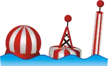
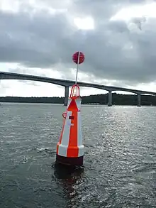
They are recognisable by their red-and-white vertical stripes and commonly bear a top sign in shape of a red ball. They either flash Morse code "A" (di-dah), or one long flash, occulting (more light than dark) or isophase (equal light and dark) every 10 seconds (L Fl 10s).[2]
In the United States, safe water marks are printed with the initials of their associated waterways or localities.
See also
References
- "Safe Water Marks" (PDF). IALA. Archived from the original (PDF) on 2007-12-14.
- NOAA Chart 37222. http://www.charts.noaa.gov/NGAViewer/37222.shtml See the vicinity of "Hubertgat"
- Haire, Penny.Yachtmaster. Royal Yachting Association, 2009, p. 61.