Fürstenrieder Straße
The Fürstenrieder Straße is an almost five-kilometer-long[1] important inner-city connecting road in Munich. It is named after the Fürstenried Palace, which lies near its southern end.[2]
Route
The Fürstenrieder Straße leads through the districts of Laim,[3] Sendling-Westpark and Hadern[4] to the northern edge of Fürstenried and forms a section of the only partially completed Outer Ring. Over almost its entire length it is made up of six-lanes with a green central strip. It is also part of the shortest inner-city connection between the Bundesautobahn 8 (Westast) and the Bundesautobahn 95.
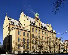
The road starts at Landsberger Straße in Laim as the southern continuation of Wotanstraße. It runs in a straight line to the south, crosses Agnes-Bernauerstraße and Gotthardstraße and crosses the Bundesautobahn 96 at junction 38. It passes close to Westpark, from which it is separated only by several school buildings (Erasmus-Grasser-Gymnasium,[5] Ludwigsgymansium).[6] It then passes Waldfriedhof[1] to the east. It crosses under the Bundesautobahn 95 leading into the city at exit 2 Kreuzhof and changes there into Boschetsrieder Straße and therefore into a west-eastern tangential road of the Outer Ring.
History

The current route of Fürstenrieder Straße used to be an alleyway connecting Nymphenburg Palace[7] and Fürstenried Palace. The expansion into an inner-city main road already began in the 1950s before the Munich General Traffic Plan was drawn up in 1963, in which it was included as part of the Tangente 5-West.[8]
From 1948 to 1966, a trolleybus line ran through the Fürstenrieder Straße (until 1961 as line O32).
Since 2005, the construction of a tram in Fürstenrieder Straße has been the subject of controversial discussion, and the timetable for its implementation is still open.[8]
References
- "Fürstenrieder Straße" (in German). 17 May 2010. Retrieved 5 August 2019.
- "Schloss Fürstenried" (in German). münchen.de. Retrieved 5 August 2019.
- "Wohnen mit idyllischem Charakter" (in German). münchen.de. Retrieved 5 August 2019.
- "Abgrenzung Hadern" (in German). münchen.de. Retrieved 5 August 2019.
- "Impressum" (in German). Erasmus-Grasser-Gymnasium München. Retrieved 5 August 2019.
- "Impressum" (in German). Ludwigsgymnasium München. Retrieved 5 August 2019.
- "Anfahrt Schloss Nymphenburg" (in German). Bayerische Verwaltung der staatlichen Schlösser, Gärten und Seen. Retrieved 5 August 2019.
- "Westtangente" (in German). Münchner Verhehrsgesellschaft. Archived from the original on 3 April 2019. Retrieved 5 August 2019.