Druridge Bay Country Park
Druridge Bay Country Park is adjacent to Druridge Bay between Amble and Cresswell, on the coastline of Northumberland, England. The country park was opened officially in 1989, but works had been ongoing since the 1970s to remediate the site after opencast coaling operations. The park is accessible by vehicle from the A1068 road, and is located on the England Coast Path. Public transport can be taken near to the park's closest village, which involves a 15-minute walk to get to the park.
| Druridge Bay Country Park | |
|---|---|
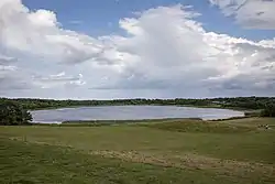
 Ladyburn Lake at Druridge Bay Country Park | |
 | |
| Type | Country park |
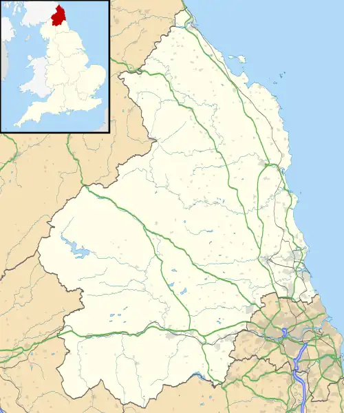
| Location | Druridge Bay, Northumberland |
| Nearest town | Amble |
| OS grid | NU269000[1] |
| Coordinates | 55.294°N 1.577°W[1] |
| Area | 65.8 acres (26.6 ha) |
| Elevation | 21 feet (6.3 m) |
| Established | 1970 (open 1989) |
| Operated by | Northumberland County Council |
| Open | All year |
| Designation | Northumberland Shore SSSI (partial) |
| Parking | Pay and display |
| Public transit access | Hadston, Red Row; bus service 518 |
| Website | Official website |
History
The eastern edge of the park, where it meets the coastline, was used in the Second World War as an aerial gunnery and target practice range. This was administered by the nearby RAF Acklington station.[2] Opencasting and quarrying were the previous industries in the area, and when these ceased, the site was redeveloped into a country park.[3] Coal has been worked in the area progressively since the 1940s, which has left several large ponds and pools as an after effect of the coaling operations. Druridge Country Park is situated mostly on the former Coldrife surface mine,[4] which was granted permission in 1965 and worked progressively over eight years.[5]
The lake is fed by Lady Burn, and was created in the early 1970s, starting to fill with water from 1971.[6] However, the water leaked out through old mine workings and had emptied by 1974. In 1983, clay from nearby coal workings was used to re-line the bottom of the lake and it was allowed to refill.[7]
The park is 12 miles (19 km) south east of Alnwick,[8] 3 miles (4.8 km) south of Amble,[9] and 4 miles (6.4 km) north of Widdrington.[10] It has a junction off the A1068 road, and is also accessible by bus from the nearby villages of Hadston and Red Row (No. 518, which includes a 15-minute walk to the country park).[11][12]
Whilst access was available for some time before official opening,[7] the park was deemed to have been opened in July 1989 when the visitor centre was unveiled.[13] In 1992, the Northumberland Shore SSSI was established, with the easternmost part of the park falling within the zone of the SSSI.[14] In 2000, the park attracted 100,000 visitors[15] Further investment in 2020 included a refurbishment of the visitor centre and the creation of an area for caravans and campers.[16] Management of the park is undertaken by Northumberland County Council.[17]
Activities
The park covers an area of 65.8 acres (26.6 ha)[9] with the centrepiece being the 25-acre (10-hectare), 16-foot (4.9 m) deep Ladyburn Lake.[18][19] The lake is used for variety of watersports such as kayaking, sailing,[20] paddleboarding, windsurfing, canoeing,[21] and wild swimming.[22] The park has a visitor centre, cafe, toilets, a play park and is wheelchair accessible.[12][23] Walking is another popular activity and the eastern edge of the site has the England Coastal Path running through it.[24]
The park was the setting of time trials for the 1995 World Cross Country running championships,[25] and the national triathlon championships in 2009.[26]
Wildlife
Birds are particularly prevalent in the park as it is near the coast and has standing water. Those spotted at the park are bullfinch, crossbill, kingfisher, redpoll, siskin, willow tit, gadwall, red-breasted mergansers, and long-tailed duck. During the winter, the coast and park are host to divers, grebes, geese, whooper and bewick swans.[27][28]
References
- "Ladyburn Lake, Northumberland". getoutside.ordnancesurvey.co.uk. Retrieved 2 August 2021.
- "Druridge Bay Air Gunnery and Bombing Range" (PDF). assets.publishing.service.gov.uk. 1939. pp. 6, 15. Retrieved 2 August 2021.
- "Durham Mining Museum - Druridge Opencast". www.dmm.org.uk. Retrieved 3 August 2021.
- "Highthorn Proposed Surface Mine" (PDF). banks group.co.uk. p. 3. Retrieved 5 August 2021.
- "Opencast Mining Site, Coldrife - Tuesday 23 November 1965 - Hansard - UK Parliament". hansard.parliament.uk. Retrieved 3 August 2021.
- Tandy, Cliff (1975). Landscape of industry. London: L. Hill. p. 169. ISBN 0-2494-4139-X.
- Smith, Ian (1988). Northumbrian coastline : Berwick-upon-Tweed to North Shields. Alnwick: Sandhill Press. p. 87. ISBN 0-946098-10-7.
- Long, Peter; McMartin, K. E.; Palese, M.; Tephly, T. R. (2005). The hidden places of Northumberland and Durham (6 ed.). Aldermaston: Travel. p. 84. ISBN 1904434371.
- "Druridge Bay Country Park". woodlandtrust.org.uk. Retrieved 3 August 2021.
- Gillham, John (2014). 50 walks in Durham & Northumberland : 50 walks of 2-10 miles (3 ed.). Basingstoke, Hampshire: AA Publishing. p. 82. ISBN 9780749575670.
- "Newcastle - Morpeth - Amble - Alnwick 518" (PDF). travelnortheast.co.uk. Retrieved 3 August 2021.
- Abbott, Louise, ed. (2009). Where to go wild in Britain. London: Dorling Kindersley. p. 20. ISBN 978-1-4053-3512-6.
- "From Coal Mine to Country Park". The Planner. London: Royal Town Planning Institute. 75 (11–35): 6. 28 July 1989. ISSN 0309-1384.
- "Northumberland Shore" (PDF). designatedsites.naturalengland.org.uk. Retrieved 3 August 2021.
- "Ryder Cup bid aided by 'Oscar' for hotel". infoweb.newsbank.com. 27 October 2000. Retrieved 2 August 2021.
- Smith, Ian (2 July 2020). "£300,000 refurbishment of Northumberland coast visitor centre finished". www.northumberlandgazette.co.uk. Retrieved 3 August 2021.
- "Northumberland and North Tyneside Shoreline Management Plan 2" (PDF). northumberland.gov.uk. p. 196. Retrieved 5 August 2021.
- Fisher, Stuart G. (2019). Coastal Britain : England & Wales : celebrating the history, heritage and wildlife of Britain's shores. London: Adlard Coles. p. 52. ISBN 978-1472958693.
- "Northumberland Coast Visitor Guide". northumberlandcoastaonb.org. p. 56. Retrieved 2 August 2021.
- Hall, Gemma (2019). Northumberland : including Hadrian's Wall and the coast : local, characterful guides to Britain's special places (2 ed.). Chalfont St Peter, Bucks, England: Bradt. p. 57. ISBN 9781784776084.
- Hall, Gemma (2012). Slow Northumberland & Durham : including the border country, Newcastle & Hadrian's Wall. Chalfont St. Peter: Bradt Travel Guides. p. 63. ISBN 9781841624334.
- "Ladyburn Lake". outdoorswimmer.com. Retrieved 3 August 2021.
- "Alnmouth to Druridge Bay". sustrans.org.uk. Retrieved 3 August 2021.
- "44-mile public path opens up North East coastline". www.northumberlandgazette.co.uk. 26 July 2018. Retrieved 3 August 2021.
- Powell, David (4 March 1995). "Top runners ignore cross country trials". The Times. No. 65, 206. p. 38. ISSN 0140-0460.
- "Athletes set for heartbreak Ridge". infoweb.newsbank.com. 18 June 2009. Retrieved 2 August 2021.
- Almond, John (20 December 2014). "Milder weather makes some linger for longer". infoweb.newsbank.com. Retrieved 5 August 2021.
- "Druridge Bay Country Park". birdwatchingsites.co.uk. 23 September 2014. Retrieved 5 August 2021.