Jahra Governorate
Al-Jahra Governorate (Arabic: محافظة الجهراء Muḥāfaẓat al-Ǧahrāʾ) is one of the six governorates of Kuwait.[2] It is the largest Governorate in Kuwait. It includes the town of Al Jahra, most of the northern and western parts of Kuwait, several islands (among them Bubiyan Island),[3] and also western districts of Kuwait City. It also contains most of Kuwait's arable land. Al Jahra also has some historic relevance to Kuwait's history.[4] The Red Palace or Al Qasr Al Ahmar is the most important historical landmark there.[5]
Al-Jahra Governorate
محافظة الجهراء | |
|---|---|
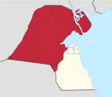 Map of Kuwait with Al-Jahra highlighted | |
| Coordinates (Al-Jahra): 29.337°N 47.658°E | |
| Country | |
| Districts | 25 |
| Government | |
| • Governor | Fahad Ahmed Al-Ameer |
| Area | |
| • Total | 11,230 km2 (4,340 sq mi) |
| Population (June 2014)[1] | |
| • Total | 491,392 |
| • Density | 44/km2 (110/sq mi) |
| Time zone | UTC+03 (AST) |
| ISO 3166 code | KW-JA |
Historically, Al Jahra was an agricultural oasis village and most locals were farmers.[6][7] Al Jahra's most notable residents included Sheikh Thuwainy Bin Abdullah Al-Saadoun (Sheikh of Al-Muntafiq) in 1786, when he fled from Baghdad to Suleiman Pasha. He wanted to occupy Basra and Sheikh Abdullah Al-Sabah hosted him until he returned to Baghdad after he was pardoned by the Iraqi governor.
In 1925, Al-Jahra was under the administrative or governmental jurisdiction of Kuwait City, and the population lived on the cultivation of palm trees and a little wheat and barley. Al Jahra contained 170 houses including the palace of Pasha al-Naqib and the palace of the Mubarak al-Sabah. Nowadays Al Jahra is a modern city and farming has been reduced to various small farms. The geographic midpoint of Kuwait is located in this governorate.
Districts
- Abdali
- Al-Baith
- Al Jahra
- Al-Kwaisat
- Al-Mutlaa
- Alnaeem
- Alnaseem
- Aloyoon
- Alqaser
- Alretqah
- Alroudhatain
- Alsalmy
- Alsubbyah
- Alsulaibya
- Alwaha
- Amghara
- Bubiyan Island
- Jaber Al Ahmad
- Kabed
- Kazma
- Om Alaish
- Saad Alabdaullah City
- Silk City
- Taimaa
- Warbah island
Government
Salim Sabah Nasir Mubarak I became governor of the Jahra Governorate in 1985.[8]
Towns
- Al Jahra'
- Al `Ulaymiyah
- Al `Arfajiyah
- Umm Ghatti
- Dulay` ar Rukham
- Ghudayy
- Bahrat al `Awjah
- Khawr al `Awjah
- Jazirat Bubiyan
- Markaz Warbah
- Jazirat Warbah
- Jal az Zawr
- Tubayj
- `Ashish ad Dawhah
- As Sab`ah
- Makhfar as Sabiyah
- Al Sabahiyah
- Al `Arfajiyah
- Al Bahrah
- Al Hujayjah
- Al Mahraqah
- An Nuwaynis
- Ar Rukham
- As Sif
- Ra's al Barshah
- Qasr as Sabiyah
- Sha`ib ar Rukham
- Khawr as Sabiyah
- Ra's as Sabiyah
See also
References
- "Statistical Reports". Archived from the original on 2014-03-13. Retrieved 2014-09-03.
- "Al-Jahra | governorate, Kuwait".
- "Kuwait Islands | Beatona".
- "Exploring Kuwait's historic areas: Jahra". 31 October 2019.
- "Exploring Jahra's Red Palace". 26 September 2019.
- Farmers of Jahra
- Beaumont, Peter; Mclachlan, Keith Stanley (1985). Agricultural development in the Middle East. Wiley. pp. 285. ISBN 978-0-471-90762-6.
- Alan Rush (1987). Al-Sabah: History & Genealogy of Kuwait's Ruling Family, 1752-1987. London: Ithaca Press. ISBN 978-0-86372-081-9.
.png.webp)
.png.webp)
.png.webp)
.png.webp)
.png.webp)
.png.webp)