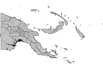
Local-level governments of Papua New Guinea
Papua New Guinea has 326 local-level governments (LLGs) comprising 6,112 wards as of 2018.[1]
 |
|---|
|
|
Administrative divisions
At the highest level, Papua New Guinea is divided into four regions, namely the Highlands, Islands, Momase, and Southern regions.
Below, Papua New Guinea has 22 province-level divisions: 20 integrated provinces, the Autonomous Region of Bougainville and the National Capital District.
Each province has one or more districts, and each district has one or more local-level government (LLG) areas. For census purposes, the LLG areas are subdivided into wards consisting of a few hundred to a few thousand individuals. Wards are further divided into census units (CU).[2]
List of local-level governments by region and province
Chimbu Province
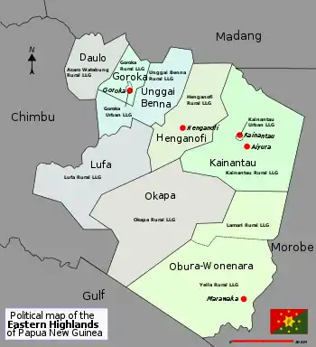
Eastern Highlands Province
Enga Province
Southern Highlands Province
Western Highlands Province
| District | District Capital | LLG Name |
|---|---|---|
| Dei District | Dei | Dei Rural (Muglamp) |
| Kotna Rural | ||
| Mount Hagen District | Mount Hagen | Mount Hagen Rural |
| Mount Hagen Urban | ||
| Mul-Baiyer District | Baiyer | Baiyer Rural |
| Lumusa Rural | ||
| Mul Rural | ||
| Tambul-Nebilyer District | Tambul | Mount Giluwe Rural |
| Nebilyer Rural |
Hela Province
| District | District Capital | LLG Name |
|---|---|---|
| Komo-Magarima District | Magarima | Hulia Rural |
| Komo Rural | ||
| Upper Wage Rural | ||
| Lower Wage Rural | ||
| Koroba-Kopiago District | Kopiago | Lake Kopiago Rural |
| North Koroba Rural | ||
| South Koroba Rural | ||
| Tari-Pori District | Tari | Hayapuga Rural |
| Tagali Rural | ||
| Tari Urban | ||
| Tebi Rural | ||
| Awi/Pori Rural |
Jiwaka Province
| District | District Capital | LLG Name |
|---|---|---|
| Anglimp-South Waghi District | Minj | Anglimp Rural |
| South Waghi Rural | ||
| Jimi District | Tabibuga | Jimi Rural |
| Kol Rural | ||
| North Waghi District | Banz | North Waghi Rural |
| Nondugl Rural |
East New Britain Province
Manus Province
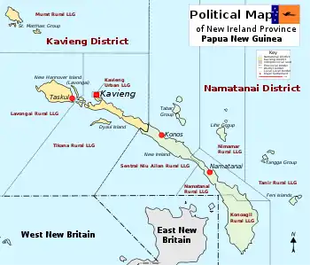
New Ireland Province
West New Britain Province
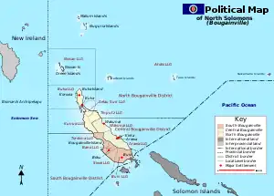
Autonomous Region of Bougainville
East Sepik Province
Madang Province
Morobe Province
Sandaun (West Sepik) Province
Central Province
Gulf Province
Milne Bay Province
Oro (Northern) Province
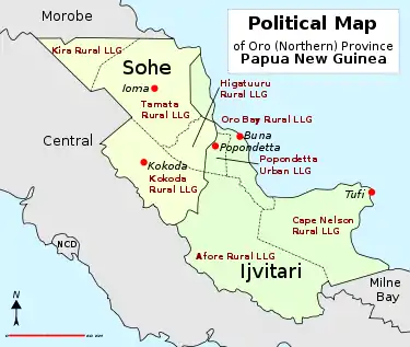
| District | District Capital | LLG Name |
|---|---|---|
| Ijivitari District | Popondetta | Afore Rural |
| Oro Bay Rural | ||
| Popendetta Urban | ||
| Safia Urban | ||
| Tufi Rural (Cape Nelson) | ||
| Sohe District | Kokoda | Higaturu Rural |
| Kira Rural | ||
| Kokoda Rural | ||
| Tamata Rural |
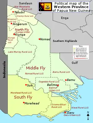
Western (Fly) Province
Demographics and postal codes
The following is a list of local-level government areas sorted by postal code. Postal codes, all prefixed with the country code PG, begin with two-digit provincial codes, followed by two-digit district codes, and finally two-digit LLG codes.[1]
See also
References
- OCHA FISS (2018). "Papua New Guinea administrative level 0, 1, 2, and 3 population statistics and gazetteer". Humanitarian Data Exchange. 1.31.9.
- "Pacific Regional Statistics - Secretariat of the Pacific Community". www.spc.int. Retrieved 7 April 2018.
- "Census Figures by Wards - Highlands Region". www.nso.gov.pg. 2011 National Population and Housing Census: Ward Population Profile. Port Moresby: National Statistical Office, Papua New Guinea. 2014.
- "Census Figures by Wards - Islands Region". www.nso.gov.pg. 2011 National Population and Housing Census: Ward Population Profile. Port Moresby: National Statistical Office, Papua New Guinea. 2014.
- "Census Figures by Wards - Momase Region". www.nso.gov.pg. 2011 National Population and Housing Census: Ward Population Profile. Port Moresby: National Statistical Office, Papua New Guinea. 2014.
- "Census Figures by Wards - Southern Region". www.nso.gov.pg. 2011 National Population and Housing Census: Ward Population Profile. Port Moresby: National Statistical Office, Papua New Guinea. 2014.
- "Final Figures". www.nso.gov.pg. 2011 National Population and Housing Census: Ward Population Profile. Port Moresby: National Statistical Office, Papua New Guinea. 2014.
- LLG boundary maps by Province (National Research Institute of Papua New Guinea)
- United Nations in Papua New Guinea (2018). "Papua New Guinea - Postal codes and Coordinates". Humanitarian Data Exchange. 1.31.9.
- OCHA FISS (2018). "Papua New Guinea administrative level 0, 1, 2, and 3 population statistics and gazetteer". Humanitarian Data Exchange. 1.31.9.
- United Nations in Papua New Guinea (2018). "Papua New Guinea Village Coordinates Lookup". Humanitarian Data Exchange. 1.31.9.
External links
- National Statistical Office, Papua New Guinea (2011 National Population and Housing Census documents)
- Mapping Application with a lot of detail down to the LLG level
- Local Level Government list – Inter Government relations department of PNG
- PNG Business Directory
- List of District Capitals
- Schedule of Polling for 2007 election – PNG Electoral Commission (document contains LLG details)
- List of LLGs by Province, with Presidents or Mayors