Denver Mountain Parks
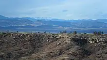
The Denver Mountain Parks system contains more than 14,000 acres (5,700 ha) of parklands in the mountains and foothills of Jefferson, Clear Creek, Douglas, and Grand counties in Colorado, west and south of Denver.


Owned and maintained by the City and County of Denver, this historic system was launched in 1910 and required Congressional approval in 1914 for the city to purchase federal lands outside its municipal limits. The mountain parks system was created “for the purpose of assuring perpetually to the residents of Denver the sublime scenery of the Rockies, the preservation of native forests and having for all time a pleasure ground in the mountains for the thousands of annual visitors to the city easily accessible.” [1]
The Denver Mountain Parks system currently consists of 22 developed parks and other undeveloped parklands that serve as open space, scenic viewsheds, and wildlife habitat. It ranges in elevation from 5,800 to 13,000 ft above sea level. Many of the parks have picnic areas and some have trails. J.J.B. Benedict designed many of the pavilions and shelters in these parks, using native stone and timber to create a “mountain architecture” style that blends into the natural sites.[2] Two shelters, one in Genesee Park and one in Dedisse Park, were built in the late 1930s by the Civilian Conservation Corps.
The Denver Mountain Park properties encompass a variety of habitats, including prairie, mountain meadow, riparian forests, montane (ponderosa pine, Douglas fir) and subalpine (Engelmann spruce) forests, and alpine tundra. Bison herds were established in wildlife preserves at Genesee Park in 1914 and later in Daniels Park as part of an effort to recover this species extirpated from Colorado.
History
Beginning in about 1909-10, the idea of a mountain park in the foothills west of Denver was promoted by John Brisben Walker and Denver's Mayor Robert W. Speer. Walker approached the Denver Real Estate Exchange, the Denver Chamber of Commerce, and the Denver Motor Club, and each of these appointed a committee to evaluate the idea. Later these were formed into a "Joint Committee of the Commercial Bodies." A city election in May 1912 gave voter approval to a mill levy to support the project.[3]
In 1912, Frederick Law Olmsted Jr. was hired to plan the park system.[4] Olmsted identified 41,310 acres (167 km²) of land that Denver should acquire for parks, mountain roads, and to protect scenic vistas.[5] Acquisition of Genesee Park began in 1912; it was the first park established and, at 2,413 acres (9.7 km²), is still the largest. The last new parks were Red Rocks Park, purchased in 1927-28; O'Fallon Park and Newton Park, donated in 1939; and Winter Park, purchased in 1939. Daniels Park was also expanded at that time.[6]
The major parks in the system were designated to the National Register of Historic Places in 1990 and 1995 as a result of multiple-property submissions that ultimately included sixteen parks.[2] Two of the highways originally built by Denver in 1912-1914, the Bear Creek Canyon Scenic Mountain Drive and the Lariat Trail Scenic Mountain Drive, were also included in that designation. These drives today are part of the Lariat Loop Scenic & Historic Byway. The designated parks are listed at National Register of Historic Places listings in Jefferson County, Colorado.
Despite their historical significance, dedicated funding for the parks was eliminated in 1955 when they became part of the Denver Parks and Recreation Department. After that time, the parks were relatively neglected, a situation that led to the formation of the Denver Mountain Parks Foundation as an advocacy group in 2004. In 2008, the Foundation and the Department joined forces to create a Master Plan for the system, the first since the original Olmsted Plan. The Plan "examines the value of the Mountain Parks to the people of Denver; provides sustainable management strategies for the funding, marketing, and protection of the currently underfunded system; and proposes both large and small improvements for the next 5-20+ years, to take this system to a level of quality commensurate with its international status." For the plan, a new logo (above) was commissioned from artist Michael Schwab to help create an identity for the park system.[6]
In 2013, the Denver Mountain Parks Foundation and the City of Denver marked the centennial of the park system with a book featuring park history, scenic and historic photographs, and a guide to the system. Denver Mountain Parks: 100 Years of the Magnificent Dream was released August 1, 2013, by John Fielder Publishing.
List of Mountain Parks
Properties owned by the City & County of Denver as Mountain Parks vary in degree of development and use. Some familiar parks are well known and regularly visited (Red Rocks Park, Echo Lake, for example); others are remote or small parcels that receive less use (Pence Park, Turkey Creek Park). Most parks have picnic areas and restrooms, but in some cases in this list, "developed" may refer only to accessibility, e.g., Bear Creek Canyon and Deer Creek Canyon. A few park names are duplicated in Jefferson County Open Space parks.[7]
| Traditional Developed Parks | Conservation/wilderness Areas | ||||
|---|---|---|---|---|---|
Developed parklands that are central to the system include well known and more modest examples established to provide mountain recreation to City residents. These parks have been used by Denver residents since the 1910s. Today they are equally used by nearby residents, Denver residents, and visitors to or residents of the entire metropolitan area.[6]
|
Considerable acreage in the Denver Mountain Parks is devoted to parcels that "were intended never to be developed."[6] Some (marked with asterisks) are adjacent to Jefferson County Open Space parks and may have trail access as a result of cooperative efforts. Many are surrounded by private property and have no public access. These conservation tracts include:
|
References
- "Introduction to the Denver Mountain Parks System, from 1913 brochure". 1913. Archived from the original on September 27, 2007. Retrieved April 28, 2007.
- "Denver Mountain Parks National Register listings at History Colorado". Directory of Colorado State Register Properties. Retrieved March 10, 2012.
- Warwick M. Downing (1931). "How Denver Acquired Her Celebrated Mountain Parks" (PDF). Municipal Facts, March–April 1931.
- Olmsted, F.L. Jr. (July 17, 1912). "Memorandum to Board of Park Commissioners" (PDF). Retrieved April 28, 2007.
- Olmsted, F.L. Jr. (January 20, 1914). "Table of Lands Recommended for Acquirement, in Denver Mountain Park Lands" (PDF). Report on Land Recommended for Acquirement to Board of Park Commissioners. Retrieved April 28, 2007.
- City & County of Denver (2008). "Denver Mountain Parks Master Plan, online version". Archived from the original on March 21, 2012. Retrieved November 26, 2011.
- Jefferson County Open Space website. "Open Space Parks and Maps". Retrieved December 7, 2013.
Further reading
- 1918. What the City has done in Five Years to Bring Wilderness Charm to the Masses. Municipal Facts (monthly). Vol. 1 No. 1. (and numerous other articles published in Municipal Facts 1912-1928)
- 1990. Multiple Property Documentation Form, 1990. Retrieved 2012-03-10.
- 1995. Denver Mountain Park System, multiple property submission to National Register of Historic Places.
- 2004. Noel, Thomas J. Sacred Stones: Colorado's Red Rocks Park and Amphitheatre. ISBN 0-9729530-0-0 City & County of Denver, Division of Theatres & Arenas
- 2008. Denver Mountain Parks Master Plan. Denver Parks & Recreation Department. 156 pp, plus appendices.
- 2013. Rex-Atzet, Wendy, Sally L. White, and Erika D. Walker. Denver Mountain Parks: 100 Years of the Magnificent Dream. ISBN 978-0-9860004-6-1 Denver Mountain Parks Foundation. John Fielder Publishing. 144 pp.