Tatoi Airport
Tatoi Airport (ICAO: LGTT) is an airport located north of Athens, in Decelea. It started operating in 1918[1] and it now has a single runway with a length of 1764m (not counting the 347m threshold). The airport is used by the Hellenic Air Force and is the base of the following aeroclubs:
- Athens Gliding Club
- Dekeleia Aeroclub
- Athens Aeroclub
- Mesogeion Aeroclub
Tatoi Airport Αεροδρόμιο Τατοϊου | |||||||||||
|---|---|---|---|---|---|---|---|---|---|---|---|
 | |||||||||||
| Summary | |||||||||||
| Airport type | Public/Military | ||||||||||
| Owner | Hellenic Air Force | ||||||||||
| Location | Tatoi, Decelea | ||||||||||
| Elevation AMSL | 785 ft / 239 m | ||||||||||
| Coordinates | 38°06′32.14″N 23°47′01.81″E | ||||||||||
| Runways | |||||||||||
| |||||||||||
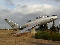
It has also been used by many other aeroclubs of Attica. Moreover, the Hellenic Air Force Museum is situated at the airport which contains many old aircraft.
Former Airlines and Destinations
| Airlines | Destinations |
|---|---|
| Air France | Akyab, Allahabad, Baghdad, Bangkok, Bushehr, Calcutta, Castelrosso, Corfu, Damascus, Dezful, Hanoi, Jodhpur, Karachi, London-Croydon, Marseille, Naples, Paris-Orly, Rangoon, Vientiane[2] |
Accidents and incidents
On 27 December 1991, Hellenic Air Force Douglas C-47B KK171 was damaged beyond repair in an accident at Tatoi Air Base. One of the six crew members was killed.[3]
Climate
Tatoi has a hot-summer Mediterranean climate (Csa) with hot summers and cool winters.
| Climate data for Tatoi, 235 m asl (1958-1997) | |||||||||||||
|---|---|---|---|---|---|---|---|---|---|---|---|---|---|
| Month | Jan | Feb | Mar | Apr | May | Jun | Jul | Aug | Sep | Oct | Nov | Dec | Year |
| Average high °C (°F) | 11.7 (53.1) |
12.5 (54.5) |
14.7 (58.5) |
19.3 (66.7) |
24.9 (76.8) |
29.9 (85.8) |
32.1 (89.8) |
31.8 (89.2) |
28.0 (82.4) |
22.5 (72.5) |
17.4 (63.3) |
13.2 (55.8) |
21.5 (70.7) |
| Average low °C (°F) | 3.2 (37.8) |
3.5 (38.3) |
4.9 (40.8) |
7.7 (45.9) |
11.9 (53.4) |
16.2 (61.2) |
19.2 (66.6) |
19.3 (66.7) |
15.6 (60.1) |
11.8 (53.2) |
7.9 (46.2) |
4.9 (40.8) |
10.5 (50.9) |
| Average precipitation mm (inches) | 69.2 (2.72) |
48.6 (1.91) |
51.1 (2.01) |
26.2 (1.03) |
20.4 (0.80) |
9.8 (0.39) |
10.0 (0.39) |
6.0 (0.24) |
17.6 (0.69) |
47.6 (1.87) |
60.2 (2.37) |
83.9 (3.30) |
450.6 (17.72) |
| Source: Hellenic National Meteorological Service[4] | |||||||||||||
References
- ΔΗΜΗΤΡΗΣ ΒΟΓΙΑΤΖΗΣ Δρ. Ιστορικός Μουσείου ΠΑ, ΜΑ, Phd. "Συνοπτική Ιστορία του Α εροδρομίου Τατοίου" (PDF). Ελευθερο Βήμα Αχαρνών. Retrieved 13 November 2015.
{{cite web}}: CS1 maint: multiple names: authors list (link) - "Air France".
- "KK171 Accident description". Aviation Safety Network. Retrieved 24 June 2010.
- "Climatological Information for Tatoi, Greece". Hellenic National Meteorological Service. Archived from the original on 20 September 2016.
External links
Wikimedia Commons has media related to Dekelia Air Base.
- LGTT World Aero Data:LGTT
- Dekeleia Aeroclub website
- Mesogeion Aeroclub website
- Athens Aeroclub website
- Airliners.gr Tatoi
This article is issued from Wikipedia. The text is licensed under Creative Commons - Attribution - Sharealike. Additional terms may apply for the media files.