Dangʻara District
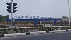
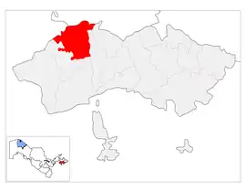
Dangʻara District (Uzbek: Dangʻara tumani) is a district of Fergana Region in Uzbekistan. The capital lies at the town Dangʻara.[1] It has an area of 430 km2 (170 sq mi)[2] and it had 180,800 inhabitants in 2022.[3] The district consists of 9 urban-type settlements (Dangʻara, Doimobod, Katta Ganjiravon, Katta Turk, Qum Qiyali, Toptiqsaroy, Tumor, Yuqori Urganji, Yangi zamon) and 8 rural communities.[1]
Dangʻara District | |
|---|---|
| Dangʻara tumani | |
 | |
 | |
| Country | Uzbekistan |
| Region | Fergana Region |
| Capital | Dangʻara |
| Established | 1939 |
| Area | |
| • Total | 430 km2 (170 sq mi) |
| Population (2022) | |
| • Total | 180,800 |
| • Density | 420/km2 (1,100/sq mi) |
| Time zone | UTC+5 (UZT) |
References
- "Classification system of territorial units of the Republic of Uzbekistan" (in Uzbek and Russian). The State Committee of the Republic of Uzbekistan on statistics. July 2020.
- "O'zbekiston Respublikasining ma'muriy-hududiy bo'linishi" [Administrative-territorial division of the Republic of Uzbekistan] (PDF) (in Uzbek). Fergana regional department of statistics.
- "Hududlar bo'yicha shahar va qishloq aholisi soni" [Urban and rural population by district] (PDF) (in Uzbek). Fergana regional department of statistics.
This article is issued from Wikipedia. The text is licensed under Creative Commons - Attribution - Sharealike. Additional terms may apply for the media files.
