Second Keihan Highway
The Second Keihan Highway (第二京阪道路, Daini Keihan Dōro), also called as Daini-Keihan Road, is a national highway and 6-laned Regional High-Standard Highways (expressway) in Japan, leading from Fushimi-ku, Kyoto through Kansai Science City to Kadoma, Osaka. This road is a bypass of Japan National Route 1.

Second Keihan Highway around Hirakata City
Expressway part
 | |
|---|---|
| 国道1号 | |
| Route information | |
| Maintained by West Nippon Expressway Company | |
| Length | 35.7 km (22.2 mi) |
| Existed | 2003–present |
| Component highways | |
| Major junctions | |
| North end | Kamogawa-nishi IC in Minami-ku, Kyoto |
| South end | Kadoma Junction in Kadoma, Osaka |
| Location | |
| Country | Japan |
| Highway system | |
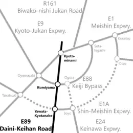
Map of Daini-Keihan Road (black) and expressways (gray) around Kyoto City. Roads and junctions under planning are shown by dotted lines.
This expressway is officially referred to as the Second Keihan Highway and the Rakunan Connecting Highway (洛南連絡道路, Rakunan Renraku Dōro). It is signed E89 under Ministry of Land, Infrastructure, Transport and Tourism's "2016 Proposal for Realization of Expressway Numbering."[1] The length of this road is 35.7 km.
Interchanges and features
- IC - interchange, SIC - smart interchange, JCT - junction, SA - service area, PA - parking area, BS - bus stop, CB - snow chains, TN - tunnel, BR - bridge, TB - Toll Gate
| Prefecture | Location | km | Exit | Name | Connections | Bus stop | Notes |
|---|---|---|---|---|---|---|---|
| Through to Inariyama Tunnel bound for Yamashina | |||||||
| Kyoto | Fushimi-ku, Kyoto | 0.0 | 8-02 | Kamogawa-higashi IC | – | ||
| Minami-ku, Kyoto | 0.6 | — | Kamogawa-nishi TB | – | |||
| 0.6 | 8-03 | Kamogawa-nishi IC | – | ||||
| 2.2 | 8-04 | Kamitoba IC | – | ||||
| Fushimi-ku, Kyoto | Kyoto-minami JCT | Planned Interchange | |||||
| 2.7 | 8-06 | Jonangu-kita IC | – | ||||
| 4.0 | 8-07 | Jonangu-minami IC | – | ||||
| 5.4 | 8-08 | Fushimi IC | Kyoto Pref. Route 35 (Otsu-Yodo Route) | – | |||
| 7.9 | — | Oguraike TB | - | ||||
| 8.3 | 1 | Oguraike IC | – | ||||
| Kumiyama | 9.4 | 2 | Kumiyama JCT | - | |||
| 12.2 | 3 | Kumiyama-minami IC | Kyoto Pref. Route 15 (Uji-Yodo Route) | - | |||
| Yawata | 12.9 | 4 | Yawata-higashi IC | Kyoto Pref. Route 22 (Yawata-Kizu Route) | - | ||
| 16.1 | 4-1 | Yawata-Kyotanabe JCT | - | ||||
| Kyotanabe | 16.4 | 5 | Kyotanabe TB/Kyotanabe Matsui IC | - | |||
| 17.2 | — | Kyotanabe PA/BS | S | ||||
| Osaka | Hirakata | 18.8 | 6 | Hirakata-higashi IC | Osaka Pref. Route 17 (Hirakata-Takatsuki Route) |
- | |
| 20.4 | 7 | Hirakata Gakken IC | - | ||||
| Katano | 22.0 | 8 | Katano-kita IC | Osaka Pref. Route 7 (Hirakata-Yamatokōriyama Route) | - | ||
| Hirakata | 25.9 | 9 | Katano-minami IC | Osaka Pref. Route 20 (Hirakata-Tondabayashi-Izumisano Route) |
- | ||
| Neyagawa | 26.8 | 10 | Neyagawa-kita IC | - | |||
| — | Neyagawa Shoji Tunnel | - | Length - 780m | ||||
| 31.5 | 11 | Neyagawa-minami IC | - | ||||
| Kadoma | 34.8 | 12 | Daini Keihan Kadoma IC | Osaka Pref. Route 2 (Osaka Center Circular Route) Osaka Pref. Route 15 (Yao-Ibaraki Route) |
- | ||
| 35.7 | - | Kadoma TB | - | ||||
| 35.7 | 3-1 | Kadoma JCT | - | ||||
Highway Part
The length of this road is 29.7 km.
References
- "Japan's Expressway Numbering System". www.mlit.go.jp.
External links
Wikimedia Commons has media related to Daini-Keihan Road.
| Routes | |
|---|---|
| Former Routes | |
This article is issued from Wikipedia. The text is licensed under Creative Commons - Attribution - Sharealike. Additional terms may apply for the media files.