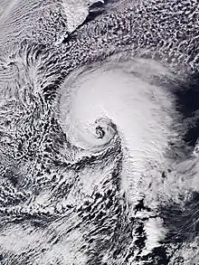
Cyclolysis
Cyclolysis is a process in which a cyclonic circulation weakens and deteriorates. Cyclolysis is the opposite of cyclogenesis.[1]

Extratropical cyclones
Extratropical cyclones usually undergo cyclolysis after an occluded front forms, which separates the center of the cyclone from the warm air. With the center of the cyclone surrounded by cool air, the temperature difference or baroclinity begins to decline, and the jet stream persisting over the strongest areas of baroclinity which is not over the center of the cyclone, which makes it so that the jet stream is unable to support the system. This usually causes decay and dissipation of the cyclone.[2][3] When an extratropical cyclone has completed cyclolysis, it usually is not connected to any weather fronts.[4] Extratropical cyclones in the northern hemisphere tend to undergo cyclolysis over the northeast Atlantic Ocean, northwestern Europe, the Gulf of Alaska, the Pacific Northwest, northeast Canada, central Russia, or the eastern Mediterranean sea.[5][6][7] In the southern hemisphere, most extratropical cyclones undergo cyclolysis north of 50°S.[8]
Tropical cyclones
Tropical cyclones often undergo cyclolysis after making landfall, especially if the land is mountainous as the friction with the terrain is increased.[9] Its supply of warm, moist maritime air is also cut off when it moves over land.[9] However, the brown ocean effect may cause the tropical cyclone to strengthen or maintain its strength over land. A tropical cyclone may also undergo cyclolysis if it moves over water cooler than 26.5 °C (79.7 °F) as this will cause it to lose its tropical characteristics and become a remnant low. However, these remnant cyclones may persist for a few more days. Excessive wind shear can also cause cyclolysis as it causes the convection that powers the tropical cyclone to move away from the center.[10]
Mesocyclones
Mesocyclones are localized storms, approximately 2 km (1.2 mi) to 10 km (6.2 mi) in diameter within strong thunderstorms. Thunderstorms containing persistent mesocyclones are supercell thunderstorms. Mesocyclones typically undergo cyclolysis when the gust front of the storm blocks off the updraft. At this point, cyclonic circulation weakens, and tornadic supercells lift off the ground. The thunderstorm begins to dissipate as well.[11]
References
- "Cyclolysis | meteorology". Encyclopedia Britannica. Retrieved 2021-03-24.
- "Cyclogenesis | meteorology". Encyclopedia Britannica. Retrieved 2021-03-24.
- "Meteorology for Scientists and Engineers, 3rd Ed" (PDF). Archived (PDF) from the original on 2017-06-29.
- "13.1: Cyclone Characteristics". Geosciences LibreTexts. 2020-01-22. Retrieved 2021-03-24.
- "A stochastic model for the lifecycle and track of extreme extratropical cyclones in the North Atlantic" (PDF).
- "Extratropical Storm Tracks" (PDF). Archived (PDF) from the original on 2018-11-05.
- Martin, Jonathan E.; Grauman, Rhett D.; Marsili, Nathan (2001). "Surface Cyclolysis in the North Pacific Ocean. Part I: A Synoptic Climatology". Monthly Weather Review. 129 (4): 748–765. Bibcode:2001MWRv..129..748M. doi:10.1175/1520-0493(2001)129<0748:SCITNP>2.0.CO;2.
- Simmonds, Ian; Keay, Kevin (2000). "Mean Southern Hemisphere Extratropical Cyclone Behavior in the 40-Year NCEP-NCAR Reanalysis". Journal of Climate. 13 (5): 873. Bibcode:2000JCli...13..873S. doi:10.1175/1520-0442(2000)013<0873:MSHECB>2.0.CO;2.
- "Hurricane FAQ". Archived from the original on 2021-02-17.
- Chang, Chih-Pei (2004). East Asian Monsoon. World Scientific. ISBN 978-981-270-141-1.
- Glossary of Meteorology (June 2000). "Mesocyclone". American Meteorological Society. Retrieved 2006-12-07.
