List of listed buildings in Cranston, Midlothian
List
| Name | Location | Date Listed | Grid Ref. [note 1] | Geo-coordinates | Notes | LB Number [note 2] | Image |
|---|---|---|---|---|---|---|---|
| Preston Hall Policies, Walled Garden Including Sheds, Gazebos, Glass Houses, Sundial And Gardener's House | 55°52′58″N 2°58′22″W | Category A | 777 |  Upload Photo | |||
| Preston Hall Policies, Icehouse | 55°52′56″N 2°58′32″W | Category C(S) | 778 | Upload Photo | |||
| Chesterhill, The Old Windmill | 55°52′30″N 3°00′20″W | Category B | 751 | Upload Photo | |||
| Cranstoun Riddel, Former Coach-Houses And Stable Including Boundary Walls And Gatepiers | 55°52′48″N 2°59′06″W | Category C(S) | 767 | Upload Photo | |||
| Cousland Park, Including Former Orchard To Sw | 55°54′33″N 2°58′28″W | Category B | 774 | Upload Photo | |||
| Cousland, Smiddy And Cottage | 55°54′20″N 2°59′45″W | Category B | 776 | Upload Photo | |||
| Preston Hall Policies, Stables Including Kennels, Piggery, Pheasantry And Cottages | 55°52′58″N 2°58′00″W | Category A | 113 | Upload Photo | |||
| Pathhead, Stair Arms Hotel | 55°52′22″N 2°58′48″W | Category B | 49106 | Upload Photo | |||
| Preston Hall Policies, Keeper's Lodge, Boundary Walls, Gatepiers And Gates | 55°52′58″N 2°57′35″W | Category C(S) | 49108 | 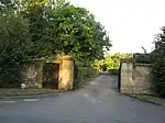
| |||
| Redrow Cottages | 55°52′56″N 2°57′32″W | Category C(S) | 49109 | Upload Photo | |||
| Airfield Farm, Including Farmhouse And Steading | 55°53′56″N 2°58′45″W | Category C(S) | 51734 | Upload Photo | |||
| Preston Hall Policies, North Gate | 55°53′38″N 2°57′24″W | Category A | 745 | Upload Photo | |||
| Preston Hall Policies, The Lions Gate | 55°52′34″N 2°58′21″W | Category A | 746 | 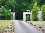
| |||
| Tyne Bridge | 55°52′29″N 2°58′23″W | Category B | 747 | Upload Photo | |||
| Oxenfoord Policies, Icehouse | 55°52′33″N 2°58′26″W | Category C(S) | 770 | Upload Photo | |||
| Edgehead Farmhouse | 55°52′36″N 3°00′18″W | Category C(S) | 49101 | Upload Photo | |||
| Oxenfoord Policies, Middle Lodge | 55°52′40″N 2°59′09″W | Category C(S) | 6637 | Upload Photo | |||
| Cranstoun House (Former Manse), Including Service Buildings And Walled Garden | 55°52′16″N 2°59′22″W | Category B | 6567 | Upload Photo | |||
| Preston Dene House And Former Office Block | 55°52′43″N 2°57′13″W | Category B | 748 | Upload Photo | |||
| Cranstoun Riddel, Cranstoun Parish Church, Including Churchyard, Boundary Walls, Gatepiers And Gates | 55°52′45″N 2°59′08″W | Category B | 766 | Upload Photo | |||
| Oxenfoord Policies, North Lodge And Boundary Wall | 55°53′03″N 2°59′25″W | Category B | 771 | Upload Photo | |||
| Edgehead Lodge, Including Boundary Wall And Gatepiers | 55°52′38″N 3°00′25″W | Category C(S) | 49102 | Upload Photo | |||
| Oxenfoord Policies, Walled Garden And Gardener's House | 55°52′45″N 2°58′55″W | Category C(S) | 49105 | Upload Photo | |||
| Oxenfoord Mains House And Boundary Walls | 55°53′35″N 2°58′06″W | Category B | 772 | Upload Photo | |||
| Oxenfoord Mains, Steading | 55°53′36″N 2°58′08″W | Category C(S) | 773 | Upload Photo | |||
| Chesterhill, Sauchenside Farmhouse And Steading | 55°52′21″N 2°59′44″W | Category C(S) | 750 | Upload Photo | |||
| Tyne Water, Oxenfoord Bridge | 55°53′44″N 2°57′47″W | Category B | 752 | Upload Photo | |||
| Cranstoun Riddel, Former Factor's House | 55°52′48″N 2°59′13″W | Category B | 49100 | Upload Photo | |||
| Oxenfoord Policies, Cranstoun Dean Bridge | 55°52′33″N 2°58′35″W | Category B | 49103 | Upload Photo | |||
| Oxenfoord Policies, South Lodge Including Boundary Walls, Gates And Gatepiers | 55°52′18″N 2°58′40″W | Category B | 6638 | Upload Photo | |||
| Cranston, Junction Of A68 And A6093, War Memorial | 55°53′03″N 2°59′27″W | Category C(S) | 49099 | Upload Photo | |||
| Oxenfoord Policies, Former Cranstoun Churchyard Including Boundary Wall, Gatepiers, Urns, Gates And Monuments | 55°52′47″N 2°58′51″W | Category B | 49104 | Upload Photo | |||
| Preston Hall Policies, The Temple | 55°53′14″N 2°58′07″W | Category A | 779 | Upload Photo | |||
| Oxenfoord Castle | 55°52′44″N 2°58′46″W | Category A | 768 | Upload Photo | |||
| Oxenfoord Viaduct | 55°52′46″N 2°58′46″W | Category A | 769 | .jpg.webp)
| |||
| Preston Hall | 55°52′52″N 2°58′11″W | Category A | 775 | Upload Photo | |||
| Preston Cottage, Coach House, Boundary Walls And Gatepiers | 55°52′37″N 2°57′45″W | Category C(S) | 49107 | Upload Photo | |||
| Ford Village, Woodlands (Formerly Old U.P. Manse), Including Boundary Walls, Gatepiers And Gates | 55°52′11″N 2°58′57″W | Category C(S) | 749 | Upload Photo |
Key
The scheme for classifying buildings in Scotland is:
- Category A: "buildings of national or international importance, either architectural or historic; or fine, little-altered examples of some particular period, style or building type."[1]
- Category B: "buildings of regional or more than local importance; or major examples of some particular period, style or building type, which may have been altered."[1]
- Category C: "buildings of local importance; lesser examples of any period, style, or building type, as originally constructed or moderately altered; and simple traditional buildings which group well with other listed buildings."[1]
In March 2016 there were 47,288 listed buildings in Scotland. Of these, 8% were Category A, and 50% were Category B, with the remaining 42% being Category C.[2]
Notes
- Sometimes known as OSGB36, the grid reference (where provided) is based on the British national grid reference system used by the Ordnance Survey.
• "Guide to National Grid". Ordnance Survey. Retrieved 12 December 2007.
• "Get-a-map". Ordnance Survey. Retrieved 17 December 2007. - Historic Environment Scotland assign a unique alphanumeric identifier to each designated site in Scotland, for listed buildings this always begins with "LB", for example "LB12345".
References
- All entries, addresses and coordinates are based on data from Historic Scotland. This data falls under the Open Government Licence
- "What is Listing?". Historic Environment Scotland. Retrieved 29 May 2018.
- Scotland's Historic Environment Audit 2016 (PDF). Historic Environment Scotland and the Built Environment Forum Scotland. pp. 15–16. Retrieved 29 May 2018.
This article is issued from Wikipedia. The text is licensed under Creative Commons - Attribution - Sharealike. Additional terms may apply for the media files.