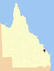
County of Clinton, Queensland

The County of Clinton is a county (a cadastral division) in Queensland, Australia. It is centred on the city of Gladstone and includes most of the Gladstone Region.[1][2] The county was created on 1 September 1855 by royal proclamation under the Waste Lands Australia Act 1846.[3] On 7 March 1901, the Governor issued a proclamation legally dividing Queensland into counties under the Land Act 1897.[4] Its schedule described Clinton thus:

Bounded on the south by the county of Yarrol; on the west by the county of Rawbelle and the eastern watershed of Callide Creek and the Don River; on the north by the northern watershed of the Calliope River; and on the east by the Pacific Ocean and the county of Flinders.

Clinton
Queensland
Location within Queensland
Lands administrative divisions around Clinton:
Deas Thompson Deas Thompson Coral Sea
Raglan Clinton Coral Sea
Pelham
Rawbelle
Yarrol Flinders

Parishes

Clinton is divided into parishes, as listed below:

ParishLGACoordinatesTowns
AlmaGladstone24°02′S 150°51′E
AucklandGladstone23°52′S 151°13′EClinton
BalaclavaGladstone23°59′S 150°45′E
BarmundooGladstone24°12′S 151°07′E
BompaGladstone24°36′S 151°22′E
BooroomGladstone24°05′S 151°05′E
BoyneGladstone24°01′S 151°18′EBenaraby
CalliopeGladstone23°52′S 151°09′EYarwun, Targinie
DawesGladstone24°35′S 151°13′E
DegalgilGladstone24°24′S 151°08′E
DiglumGladstone24°17′S 151°03′E
East StoweGladstone23°59′S 151°12′ECalliope
GatcombeGladstone23°51′S 151°21′E
GayfieldGladstone24°07′S 150°47′E
GladstoneGladstone23°52′S 151°16′EGladstone, Toolooa
IveraghGladstone24°01′S 151°23′ETannum Sands, Bangalee
MaxweltonGladstone24°08′S 150°56′E
MiltonGladstone24°24′S 151°20′ENagoorin, Ubobo
Mount LarcomGladstone23°53′S 151°01′E
O'ConnellGladstone24°07′S 151°22′EIveragh
PembertonGladstone24°14′S 151°20′E
RadleyGladstone24°28′S 151°14′E
RiverstonGladstone24°05′S 151°12′E
RuleGladstone24°31′S 151°21′EBuilyan
South TreesGladstone23°55′S 151°20′EBoyne Island
TondoonGladstone23°54′S 151°17′EGlen Eden
ToolooaGladstone23°57′S 151°16′E
West StoweGladstone23°58′S 151°07′E
WietalabaGladstone24°17′S 151°14′E

References

  1. "Clinton (entry 7449)". Queensland Place Names. Queensland Government. Retrieved 8 September 2015.
  2. Port Curtis District, County of Clinton Maps - F1 Series at Queensland Archives.
  3. "Proclamation". New South Wales Government Gazette. 29 June 1855. p. 1855:1737–1738.
  4. "A Proclamation". Queensland Government Gazette. Vol. 75. 8 March 1901. pp. 967–980.

23°50′S 151°15′E

This article is issued from Wikipedia. The text is licensed under Creative Commons - Attribution - Sharealike. Additional terms may apply for the media files.