Argyle County
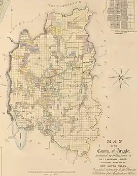
Argyle County was one of the original Nineteen Counties in New South Wales and is now one of the 141 Cadastral divisions of New South Wales. It includes the area around Goulburn. It is bounded by Lake George in the south-west, the Shoalhaven River in the east, and the Wollondilly River in the north-east.
| Argyle New South Wales | |||||||||||||||
|---|---|---|---|---|---|---|---|---|---|---|---|---|---|---|---|
 Location of Argyle | |||||||||||||||
 Argyle | |||||||||||||||
| Coordinates | 34°49′24″S 149°44′04″E | ||||||||||||||
| |||||||||||||||

Argyle County was named by Governor Macquarie after his native county in Scotland.[1] He named it while inspecting the area in 1820.[2]
In 1829 the Act for Instituting and regulating Courts of General and Quarter Sessions in New South Wales established courts in the county at Cookbundoon, Goulburn Plains and Inverary.[3] James Byrne was Assistant Surveyor for the County in 1832.[4] In 1835 Argyle had a magistrate and police force.[5]
In 1852 it had an area of 1,248,600 acres (5,053 km2) and population of 5,565.[6] It was also described as having productive land and inexhaustible water.
In 1857, Charles Cowper was a major landowner in the area, and held 19,720 acres (79.8 km2) in the county.[7] The Electoral district of Argyle was the former state electoral district for the area between 1856 and 1904. The Encyclopædia Britannica Eleventh Edition mentions Goulburn as being in the county.[8]
The Greater Argyle Council was formed in 2004 after a proposal[9] to make a new local government area to focus on the County of Argyle, formed from an amalgamation of the former City of Goulburn and parts of Mulwaree Shire. It was renamed the Goulburn Mulwaree Council in October 2004.[10]
Parishes within this county
A full list of parishes found within this county; their current LGA and mapping coordinates to the approximate centre of each location is as follows:
References
- "Argyle". Geographical Names Register (GNR) of NSW. Geographical Names Board of New South Wales.
- Richlands Homestead via Taralga, NSW Archived 2007-09-28 at the Wayback Machine
- Archives investigator, Courts of General and Quarter Sessions Archived September 3, 2007, at the Wayback Machine
- Greenwich Meadows-Farms for sale Archived August 28, 2007, at the Wayback Machine
- Police NSW, history docs, Argyle Police Force Archived August 30, 2007, at the Wayback Machine
- "Old Welsh Books with English Translations", The Land of Gold: the Companion for the Welsh Emigrant to Australia, 1852
- "Sir Charles Cowper (1807-1875)". Former members of the Parliament of New South Wales. Retrieved 11 May 2019.
- Chisholm, Hugh, ed. (1911). . Encyclopædia Britannica. Vol. 12 (11th ed.). Cambridge University Press. p. 284.
- Proposal Greater Argyle City Council Archived September 26, 2007, at the Wayback Machine
- Goulburn Mulwaree Council meeting, Nov. 2004 Renaming of Argyle to Goulburn Mulwaree Archived August 29, 2007, at the Wayback Machine