Copper Plateau taiga
The Copper Plateau taiga is an ecoregion of North America, as defined by the World Wildlife Fund (WWF) categorization system and the Commission for Environmental Cooperation, in the Taiga and Boreal forests, Biome, Alaska.
| Copper Plateau taiga | |
|---|---|
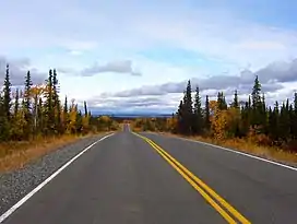
 Lake Louise, Alaska from a distance | |
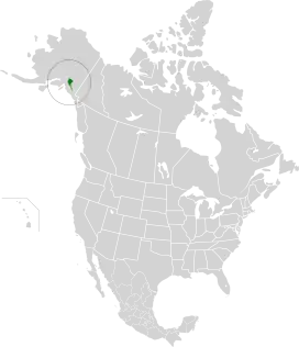
 Map of the Copper Plateau taiga. | |
| Ecology | |
| Realm | Nearctic |
| Biome | Boreal forests/taiga |
| Borders | |
| Geography | |
| Area | 17,257 km2 (6,663 sq mi) |
| Country | United States |
| State | Alaska |
| Conservation | |
| Conservation status | Relatively stable/intact[1] |
| Protected | 5,195 km² (30%)[2] |
Setting
This ecoregion consists of a large flat plateau in southeastern Alaska at 400-900m above sea level, surrounded by the high mountains and dotted with many lakes and marshes. The area is almost entirely within the Wrangell – St. Elias National Park and Preserve while the Denali Highway crosses the ecoregion in the northwest. This a very wet and damp region with up to 460mm rainfall per year and with temperatures ranging from -27 °C in winter to 21 °C in summer there are patches of shallow permafrost.[1]
Flora
To survive here plants have to be adapted to the damp conditions and the dominant tree is black spruce (Picea mariana) while the boggier areas have the dwarf birches (Betula glandulosa and Betula nana) along with shrubs and sedges such as Eriophorum angustifolium and Carex and herbs such as Menyanthes trifoliata, Petasites frigidus and Comarum palustre. Well-drained areas have communities of white spruce (Picea glauca), black cottonwood (Populus trichocarpa) and quaking aspen (Populus tremuloides).
Fauna
Lake Louise, Paxson Lake and the many other wetlands of the plain are nesting grounds for may birds including the trumpeter swan, the largest waterfowl in North America. The Copper River is home to salmon especially Chinook salmon and sockeye salmon. Mammals include the Nelchina caribou herd that migrates across the western side of the plain.
Threats and preservation
Habitat has been lost to development around Glenallen and to logging along the Copper River and on Alaska Native Regional Corporations land near Chitina.
Protected areas
A 2017 assessment found that 5,195 km², or 30%, of the ecoregion is in protected areas.[2] The eastern portion of the ecoregion is in Wrangell–St. Elias National Park and Preserve.
See also
- List of ecoregions in the United States (WWF)
- List of ecoregions in the United States (EPA) (the Copper Plateau taiga is no 117)
References
- "Copper Plateau taiga". Terrestrial Ecoregions. World Wildlife Fund.
- Dinerstein, Eric; Olson, David; et al. (June 2017). "An Ecoregion-Based Approach to Protecting Half the Terrestrial Realm". BioScience. 67 (6): 534–545. doi:10.1093/biosci/bix014. PMC 5451287. PMID 28608869.
{{cite journal}}: CS1 maint: date and year (link) Supplemental material 2 table S1b.