Communauté urbaine d'Alençon
The Communauté urbaine d'Alençon is the communauté urbaine, an intercommunal structure, centred on the city of Alençon. It is located in the Orne and Sarthe departments, in the Normandy and Pays de la Loire regions, northwestern France. It was created in December 1996.[1] Its area is 461.7 km2. Its population was 55,924 in 2018, of which 25,775 in Alençon proper.[2]
Alençon | |
|---|---|
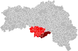 Location within the Orne department | |
| Country | France |
| Region | Normandy, Pays de la Loire |
| Department | Orne, Sarthe |
| No. of communes | 31 |
| Established | December 1996 |
| Seat | Alençon |
| Area | 461.7 km2 (178.3 sq mi) |
| Population (2018) | 55,924 |
| • Density | 121/km2 (310/sq mi) |
Composition
The communauté urbaine consists of the following 31 communes, of which 5 (Arçonnay, Champfleur, Chenay, Saint Paterne - Le Chevain and Villeneuve-en-Perseigne) in the Sarthe department:[1][3]
- Alençon
- Arçonnay
- Cerisé
- Champfleur
- Chenay
- Ciral
- Colombiers
- Condé-sur-Sarthe
- Cuissai
- Damigny
- Écouves
- La Ferrière-Bochard
- Gandelain
- Héloup
- Lalacelle
- Larré
- Lonrai
- Ménil-Erreux
- Mieuxcé
- L'Orée-d'Écouves
- Pacé
- La Roche-Mabile
- Saint-Céneri-le-Gérei
- Saint-Denis-sur-Sarthon
- Saint-Ellier-les-Bois
- Saint-Germain-du-Corbéis
- Saint-Nicolas-des-Bois
- Saint Paterne - Le Chevain
- Semallé
- Valframbert
- Villeneuve-en-Perseigne
References
- CU d'Alençon (N° SIREN : 246100663), BANATIC. Accessed 4 April 2022.
- Comparateur de territoire, INSEE. 4 April 2022.
- INSEE
This article is issued from Wikipedia. The text is licensed under Creative Commons - Attribution - Sharealike. Additional terms may apply for the media files.