Clot de la Hount
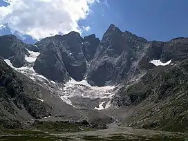
The Clot de la Hount or pic du clot de la Hount is a summit of the Pyrenees, located on the Franco-Spanish border in the Vignemale Massif, of which it is the second highest summit in the range, at 3,289 m, after Pique Longue (3,298 m).
| Clot de la Hount | |
|---|---|
 centre-left | |
| Highest point | |
| Elevation | 3,289 m (10,791 ft)[1] |
| Prominence | 40 m (130 ft) |
| Listing | List of Pyrenean three-thousanders |
| Coordinates | 42°46′23″N 0°08′59″E[1] |
| Geography | |
 Clot de la Hount Location in the Pyrenees | |
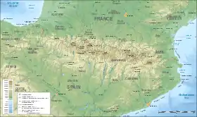
| Location | France — Spain |
| Région Communauté | Midi-Pyrénées Aragon |
| Département Province | Hautes-Pyrénées Huesca |
| Parent range | Vignemale Massif (Pyrenees) |
| Climbing | |
| Easiest route | From Glacier d'Ossoue |
Toponymy
The Clot de la Hount is a term coined by shepherds for the area near the bottom of the peak.
Hount refers to a spring source which flows intermittently (Hount meaning eye, or a passage that is sometimes open, sometimes shut).
Clot means either a ledge or a pen.
Topography
The French side is located in the Hautes-Pyrénées department, between Cauterets and Gavarnie, in the arrondissement of Argelès-Gazost which lies in the Pyrenees National Park. The southern Spanish side is in the Natural Reserve of Ordesa-Viñamala, in Torla territory, Huesca province.
References
- Source : Géoportail