Norwood, North Yorkshire
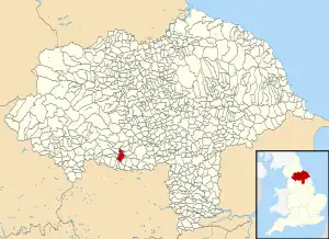
Norwood is a civil parish in the Harrogate district of North Yorkshire, England. According to the 2001 UK census, Norwood parish had a population of 200,[2] increasing to 216 at the 2011 Census.[1] The parish lies on the eastern side of the Washburn Valley, and includes the eastern side of Swinsty Reservoir.
| Norwood | |
|---|---|
| Civil parish | |
 | |
| Population | 216 (2011 census)[1] |
| OS grid reference | SE212527 |
| Civil parish |
|
| District | |
| Shire county | |
| Region | |
| Country | England |
| Sovereign state | United Kingdom |
| Post town | HARROGATE |
| Postcode district | HG3 |
| Post town | OTLEY |
| Postcode district | LS21 |
| Police | North Yorkshire |
| Fire | North Yorkshire |
| Ambulance | Yorkshire |
There is no village in the parish. The population is spread among a number of hamlets and scattered farms, including Norwood Bottom and Bland Hill. Norwood Hall is a 17th-century Grade II listed building.[3] Dob Park Bridge is a packhorse bridge, probably of 17th century origin, over the River Washburn.[4]
Norwood is pronounced locally as "Norood", just as Warwick is pronounced "Warrick".
Until 1950 the parish was known as Clifton with Norwood. It was historically a township in the parish of Fewston, and became a separate civil parish in 1866.[5]
References
- UK Census (2011). "Local Area Report – Norwood Parish (E04007403)". Nomis. Office for National Statistics. Retrieved 2 March 2020.
- UK Census (2001). "Local Area Report – Norwood Parish (36UD102)". Nomis. Office for National Statistics. Retrieved 2 March 2020.
- Historic England. "Details from listed building database (1150433)". National Heritage List for England. Retrieved 15 March 2014.
- Historic England. "Details from listed building database (1295637)". National Heritage List for England. Retrieved 15 March 2014.
- Vision of Britain website
External links
![]() Media related to Norwood, North Yorkshire at Wikimedia Commons
Media related to Norwood, North Yorkshire at Wikimedia Commons