Chorul Peninsula
Chorul Peninsula (Bulgarian: полуостров Чорул, romanized: poluostrov Chorul, IPA: [poɫuˈɔstrof ˈt͡ʃɔroɫ]) is the predominantly ice-covered 5.6 km wide peninsula projecting from Graham Coast, Antarctic Peninsula 5.6 km westwards into Beascochea Bay, and ending in Holst Point. Its shape was enhanced as a result of the adjacent Funk Glacier retreating during the last decade of 20th century and the first decade of 21st century.
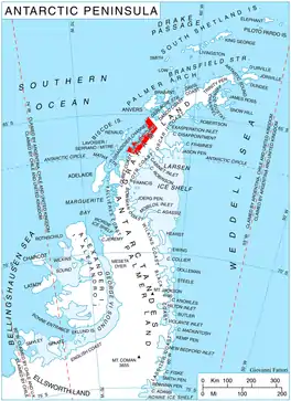
Location of Graham Coast on the Antarctic Peninsula.
The feature is named after the settlement of Chorul in Western Bulgaria.
Location
Chorul Peninsula is centred at 65°33′00″S 63°45′10″W. British mapping in 1976.
Maps
- British Antarctic Territory. Scale 1:200000 topographic map. DOS 610 Series, Sheet W 65 62. Directorate of Overseas Surveys, Tolworth, UK, 1976.
- Antarctic Digital Database (ADD). Scale 1:250000 topographic map of Antarctica. Scientific Committee on Antarctic Research (SCAR). Since 1993, regularly upgraded and updated.
References
- Chorul Peninsula. SCAR Composite Antarctic Gazetteer.
- Bulgarian Antarctic Gazetteer. Antarctic Place-names Commission. (details in Bulgarian, basic data in English)
External links
- Chorul Peninsula. Copernix satellite image
This article includes information from the Antarctic Place-names Commission of Bulgaria which is used with permission.
This article is issued from Wikipedia. The text is licensed under Creative Commons - Attribution - Sharealike. Additional terms may apply for the media files.