Chinchero District
Chinchero District is one of seven districts of the Urubamba Province in Peru.[1] It is the location for the proposed Chinchero International Airport, which would serve travelers to the Cusco Region.[2]
Chinchero
Chinchiru | |
|---|---|
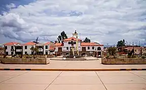
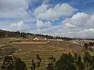
From top, clockwise: Plaza Chinchero, rural terraces, overview of the town | |
| Coordinates: 13°23′28″S 72°2′52″W | |
| Country | |
| Region | Cusco |
| Province | Urubamba |
| Founded | September 9, 1905 |
| Capital | Chinchero |
| Government | |
| • Mayor | Luis Hector Cusicuna Quispe |
| Area | |
| • Total | 94.57 km2 (36.51 sq mi) |
| Elevation | 3,762 m (12,343 ft) |
| Population (2017) | |
| • Total | 10,477 |
| • Density | 110/km2 (290/sq mi) |
| Time zone | UTC-5 (PET) |
| UBIGEO | 081302 |
| Website | munichinchero.gob.pe |
.jpg.webp)
Geography
One of the highest peaks of the district is Hatun Luychu at approximately 4,400 m (14,400 ft). Other mountains are listed below:[3]
- Ichhu Kancha
- Kunka Kunka
- K'usi Qaqa
- Pata Kancha
- Quri Qucha Punta
- Quri Qucha Qaqa
- Sinqa
- Wallata Wachana
- Wanakawri (Anta-Urubamba)
- Yuthu Pukyu
Ethnic groups
The people that live in the district are mainly indigenous citizens of Quechua descent. Quechua is the language which the majority of the population (81.49%) learnt to speak in childhood, 17.95% of the residents started speaking using the Spanish language (2007 Peru Census).[4]
Climate
Chinchero has a dry-winter subpolar oceanic climate (Köppen climate classification: Cwc), that borders very closely on both a tundra climate (Köppen climate classification: ET), and a cold semi-arid climate (Köppen climate classification: BSk).
| Climate data for Chincheros, Peru (1981–2010) | |||||||||||||
|---|---|---|---|---|---|---|---|---|---|---|---|---|---|
| Month | Jan | Feb | Mar | Apr | May | Jun | Jul | Aug | Sep | Oct | Nov | Dec | Year |
| Average high °C (°F) | 16 (61) |
16 (61) |
16 (61) |
17 (63) |
16 (61) |
16 (61) |
16 (61) |
16 (61) |
17 (63) |
18 (64) |
17 (63) |
17 (63) |
16.5 (61.7) |
| Average low °C (°F) | 4 (39) |
3 (37) |
3 (37) |
1 (34) |
−2 (28) |
−4 (25) |
−6 (21) |
−4 (25) |
−1 (30) |
1 (34) |
2 (36) |
3 (37) |
0 (32) |
| Average precipitation mm (inches) | 117 (4.6) |
81 (3.2) |
72 (2.8) |
36 (1.4) |
3 (0.1) |
3 (0.1) |
0 (0) |
9 (0.4) |
12 (0.5) |
24 (0.9) |
45 (1.8) |
51 (2.0) |
453 (17.8) |
| Average precipitation days (≥ 1.0 mm) | 17 | 10 | 13 | 7 | 2 | 2 | 0 | 2 | 4 | 6 | 8 | 9 | 81 |
| Source: WW[5] | |||||||||||||
Notable residents
The anthropologists Ed and Chris Franquemont lived among the Chinchero people during the 1970s, studying traditional textile production techniques. Their daughter Abby Franquemont, having spent her childhood within a spinning culture, later became a revivalist of hand spinning with the spindle.[6]
See also
- Center for Traditional Textiles of Cusco (Centro de Textiles Tradicionales del Cusco, CTTC)
- Lliklla
- Nilda Callañaupa Alvarez
- List of archaeological sites in Peru
References
- (in Spanish) Instituto Nacional de Estadística e Informática. Banco de Información Distrital Archived April 23, 2008, at the Wayback Machine. Retrieved April 11, 2008.
- "International Airport of Chinchero - Cusco (AICC) :: Proinversión". www.proyectosapp.pe. Retrieved 19 April 2017.
- escale.minedu.gob.pe/ UGEL map Urubamba Province (Cusco Region)
- inei.gob.pe Archived January 27, 2013, at the Wayback Machine INEI, Peru, Censos Nacionales 2007, Frequencias: Preguntas de Población: Idioma o lengua con el que aprendió hablar (in Spanish)
- "Weather Averages and Activities". World Weather Online. Retrieved 15 October 2013.
- Abby Franquemont, Respect the Spindle, spin infinite yarns with one amazing tool, Interweave (2009) ISBN 9781596681552
External links
- (in Spanish) Official municipal website
| |
|---|---|
| Acomayo | |
| Anta | |
| Calca | |
| Canas | |
| Canchis | |
| Chumbivilcas | |
| Cusco | |
| Espinar | |
| La Convención | |
| Paruro | |
| Paucartambo | |
| Quispicanchi | |
| Urubamba | |