Shımbay
Shimbay (Karakalpak: Шымбай, Shımbay), also known as Chimbay (Russian: Чимбaй, romanized: Chimbay) is a city and seat of Shimbay district in Karakalpakstan.[1] Its population is 50,400 (2016).[2]
Shimbay
Шымбай, Shımbay | |
|---|---|
City | |
| Shimbay | |
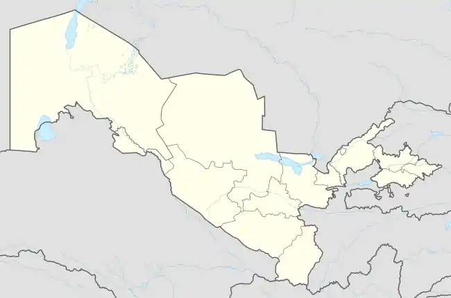 Shimbay Location in Uzbekistan | |
| Coordinates: 42°56′N 59°47′E | |
| Country | |
| Autonomous Republic | Karakalpakstan |
| District | Shimbay District |
| Elevation | 64 m (210 ft) |
| Population (2016) | |
| • Total | 50,400 |
| Time zone | UTC+5 (UZT) |
| Area code | (+998) 6144 |
Climate
Shimbay has a cold desert climate (Köppen climate classification BWk), with cold winters and hot summers. Rainfall is generally light and erratic, and occurs mainly in the winter and autumn months.
| Climate data for Shimbay (1991–2020, extremes 1937–present) | |||||||||||||
|---|---|---|---|---|---|---|---|---|---|---|---|---|---|
| Month | Jan | Feb | Mar | Apr | May | Jun | Jul | Aug | Sep | Oct | Nov | Dec | Year |
| Record high °C (°F) | 17.0 (62.6) |
27.7 (81.9) |
31.8 (89.2) |
37.1 (98.8) |
43.5 (110.3) |
43.3 (109.9) |
46.5 (115.7) |
46.0 (114.8) |
41.0 (105.8) |
33.8 (92.8) |
27.2 (81.0) |
20.0 (68.0) |
46.5 (115.7) |
| Average high °C (°F) | 0.5 (32.9) |
3.8 (38.8) |
12.5 (54.5) |
21.9 (71.4) |
29.0 (84.2) |
34.1 (93.4) |
35.6 (96.1) |
34.0 (93.2) |
27.4 (81.3) |
19.6 (67.3) |
9.3 (48.7) |
2.3 (36.1) |
19.2 (66.5) |
| Daily mean °C (°F) | −4.3 (24.3) |
−2.1 (28.2) |
5.6 (42.1) |
14.5 (58.1) |
21.6 (70.9) |
26.7 (80.1) |
28.2 (82.8) |
25.9 (78.6) |
18.9 (66.0) |
11.2 (52.2) |
3.0 (37.4) |
−2.6 (27.3) |
12.2 (54.0) |
| Average low °C (°F) | −8.3 (17.1) |
−6.9 (19.6) |
−0.3 (31.5) |
7.7 (45.9) |
14.2 (57.6) |
18.9 (66.0) |
20.6 (69.1) |
18.3 (64.9) |
11.4 (52.5) |
3.9 (39.0) |
−2.3 (27.9) |
−6.7 (19.9) |
5.9 (42.6) |
| Record low °C (°F) | −33.7 (−28.7) |
−29.6 (−21.3) |
−22.6 (−8.7) |
−10.4 (13.3) |
−0.5 (31.1) |
5.9 (42.6) |
8.4 (47.1) |
6.8 (44.2) |
−3.6 (25.5) |
−13.2 (8.2) |
−25.5 (−13.9) |
−29.7 (−21.5) |
−33.7 (−28.7) |
| Average precipitation mm (inches) | 11.2 (0.44) |
12.0 (0.47) |
18.7 (0.74) |
19.1 (0.75) |
21.0 (0.83) |
7.2 (0.28) |
2.7 (0.11) |
3.1 (0.12) |
4.6 (0.18) |
8.1 (0.32) |
15.3 (0.60) |
10.2 (0.40) |
133.2 (5.24) |
| Average rainy days | 2 | 2 | 4 | 4 | 4 | 2 | 1 | 1 | 2 | 3 | 4 | 3 | 32 |
| Average snowy days | 5 | 3 | 2 | 0.3 | 0 | 0 | 0 | 0 | 0 | 0.2 | 1 | 4 | 16 |
| Average relative humidity (%) | 75 | 71 | 63 | 52 | 48 | 44 | 44 | 47 | 50 | 57 | 68 | 73 | 58 |
| Mean monthly sunshine hours | 119 | 143 | 169 | 220 | 317 | 362 | 375 | 380 | 288 | 224 | 150 | 104 | 2,851 |
| Source 1: Pogoda.ru.net[3] | |||||||||||||
| Source 2: NOAA (sun 1961–1990)[4] | |||||||||||||
Transportation
The road south out of Shimbay connects to Xaliqabat and Nukus. Another road leads northeast to Qaraózek and Taxtakópir.
References
- "Classification system of territorial units of the Republic of Uzbekistan" (in Uzbek and Russian). The State Committee of the Republic of Uzbekistan on statistics. July 2020.
- Soliyev, A.S. Shaharlar geografiyasi [Geography of cities] (PDF) (in Uzbek). p. 143.
- "Weather and Climate-The Climate of Chimboy" (in Russian). Weather and Climate (Погода и климат). Retrieved 30 November 2019.
- "Cimbaj (Chimboy) Climate Normals 1961–1990". National Oceanic and Atmospheric Administration. Retrieved 30 November 2019.
Capital: Nukus | ||
| Districts | 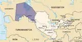 | |
| Cities | ||
| Towns |
| |
This article is issued from Wikipedia. The text is licensed under Creative Commons - Attribution - Sharealike. Additional terms may apply for the media files.