Cardrona River
The Cardrona River is in Otago in the South Island of New Zealand. It is one of the first tributaries of the Clutha River / Mata-Au, which it meets only 5 kilometres (3 mi) from the latter's origin at the outflow of Lake Wānaka.
| Cardrona River Ōrau | |
|---|---|
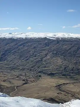 View of Cardrona Valley of the Cardrona River | |
| Native name | Ōrau (Māori) |
| Location | |
| Country | |
| Region | |
| Settlements | Wānaka, Cardrona |
| Physical characteristics | |
| Source | Crown Range |
| Mouth | Clutha / Mata-au River |
• coordinates | 44°41′S 169°12′E |
| Length | 40 kilometres (25 mi) |
| Basin features | |
| Progression | → Clutha River → Pacific Ocean |
The Cardrona flows north for 40 kilometres (25 mi) down the steep narrow Cardrona Valley. Its headwaters are near New Zealand's highest main road, the Crown Range route.[1] The river runs past the settlement of Cardona and the Cardrona skifield, then south of Wānaka township.
The original name of the river is the Ōrau. It was a traditional Māori route linking Whakatipu Waimāori (Lake Wakatipu) with lakes Wānaka and Hāwea. Ngāi Tahu recorded Ōrau as a kāinga mahinga kai (food-gathering place) where tuna (eels), pora ('Māori turnip') and weka were gathered.[2]
References
- Zanthia. "The Crown Range". 100% Pure New Zealand. New Zealand Tourism. Retrieved 28 July 2020.
- "Ōrau "Cardrona River"". Kā Huru Manu. Te Rūnanga o Ngāi Tahu. Retrieved 28 July 2020.