Calcutt, Wiltshire
Calcutt is a hamlet about 3⁄4 mile (1.2 km) east of Cricklade in Wiltshire, England. It lies near the River Thames and is divided by the A419 Swindon-Cricklade-Cirencester road.
| Calcutt | |
|---|---|
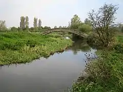 River Thames near Calcutt | |
 Calcutt Location within Wiltshire | |
| OS grid reference | SU112934 |
| Civil parish | |
| Unitary authority | |
| Ceremonial county | |
| Region | |
| Country | England |
| Sovereign state | United Kingdom |
| Post town | Swindon |
| Postcode district | SN6 |
| Dialling code | 01793 |
| Police | Wiltshire |
| Fire | Dorset and Wiltshire |
| Ambulance | South Western |
| UK Parliament | |
The River Key passes close to the west of the hamlet and joins the Thames a short distance to the north.
The Domesday Book of 1086 records a small settlement of nine households at Colecote, held by Odo of Winchester.[1] The Andrews and Dury map of 1773 and again in 1810 has the name of the hamlet as Corkett, while the Ordnance Survey map in the 1890s has Calcott[2] (not to be confused with Calcott, Kent or Calcott, Shropshire).
Calcutt has two Grade II* listed buildings: Calcutt Court Farmhouse, south of the A419, from the 18th century; and Calcutt Farmhouse, north of the road, from the late 18th or early 19th.[3][4]
References
- Calcutt in the Domesday Book
- "Cricklade". Wiltshire Community History. Wiltshire Council. Retrieved 13 May 2016.
- Historic England. "Calcutt Court Farmhouse (1023088)". National Heritage List for England. Retrieved 13 May 2016.
- Historic England. "Calcutt Farmhouse (1182844)". National Heritage List for England. Retrieved 13 May 2016.