Napoleon's Last HQ
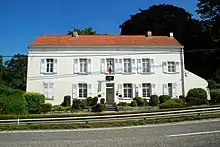
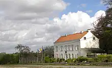
Napoleon's Last HQ (French: Le dernier QG de Napoléon) is a museum housed in the Ferme du Caillou (Caillou Farm) at Genappe, Belgium, in which the Emperor Napoleon stayed the night before the Battle of Waterloo on 18 June 1815. The site is located 4 kilometres (2.5 mi) south of the Lion of Waterloo, at Chaussée de Bruxelles 66, 1472 Genappe. Travelling north, the high road passes pass over the Waterloo battlefield through Waterloo and on to Brussels.

History
.jpg.webp)
In 1815 the farmhouse belonged to Séance de Caioux.[1][lower-alpha 1] Napoleon resided there on the night of the 17/18 of June 1815.[1] It is the site of the breakfast conference at which Napoleon told his marshals, "Wellington is a bad general, the English are bad troops, and this affair is nothing more than eating breakfast".[2]
A day after the battle, the Prussians, vowing that it should never again harbour their former enemy, burnt the farmhouse.[1]
Museum

The museum houses unique pieces, such as the Emperor's camp bed and table he used during the campaign.[3]
 Ossuary built in 1912 in the garden to house bones found in the surrounding fields
 Bust of Napoleon by made by Luigi di Quintana Bellini Trinchi in 2002
Notes
- Robert Hills notes "The French official details say, that the Emperor's" head quarters were at the farm of Oaillon, near Planchenoit. Caioux was its name, as written for me by a farmer near the spot" (Hills 1816, p. 93).
- Hills 1816, p. 93.
- Longford 1971, p. 547.
- Point 2015.
References
- Longford, Elizabeth (1971), Wellington the Years of the Sword, London: Panther, ISBN 0-586-03548-6
- Point, B.W. (Summer 2015), journal d'information officiel de la Province du Brabant wallon
- Hills, Robert (1816), Sketches in Flanders and Holland: With Some Account of a Tour Through Parts of Those Countries, Shortly After the Battle of Waterloo; in a Series of Letters to a Friend, J. Haines and J. Turner, p. 93
External links
 Media related to Ferme du Caillou at Wikimedia Commons
- Official website