Caerphilly Mountain
Caerphilly Mountain (Welsh: Mynydd Caerffili) lies between Cardiff and Caerphilly at the southern edge of the South Wales Coalfield. Its summit is 271 metres (889 ft) above sea-level.[1]
Caerphilly Mountain and Caerphilly Common

Triangulation point on the summit of Caerphilly Mountain
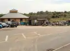
The new and old Caerphilly Mountain Snack Bar

Caerphilly Common
Since 1957 there had been a small wooden snack bar near to the summit. In September 2011 this was replaced by an eco-friendly permanent building, with under floor heating, solar panels and rainwater-flushed toilets, at a cost of £300,000.[2] The mountain includes Caerphilly Common (Welsh: Comin Caerffili).
The climb features regularly on the Tour of Britain cycle race, with double climbs in the 2012 and 2013 races.[3][4]
References
- Cardiff, Newport & surrounding area (Map). 1:50,000. Landranger. Ordnance Survey. 1985. ISBN 0-319-22171-7. Retrieved 4 January 2017.
- Caerphilly Observer Caerphilly Mountain Snack Bar gets £300,000 revamp (online article viewed 6 Sept 2011)
- Tour of Britain 2012, stage six: Leopold Koenig triumphs in Caerphilly as Jonathan Tiernan-Locke takes lead - Telegraph
- BBC News - In pictures: Tour of Britain tackles Caerphilly Mountain
This article is issued from Wikipedia. The text is licensed under Creative Commons - Attribution - Sharealike. Additional terms may apply for the media files.