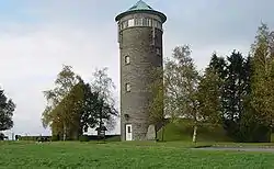
Buurgplaatz
Buurgplaatz (alternate names: Buergplaatz, Burrigplatz, Burgplatz, Buergplaz zu Huldang) is a hill in the commune of Troisvierges, in northern Luxembourg. The 559-metre-high (1,834 ft) summit lies within the Oesling region at 50.1615°N 6.0281°E.[1]
In 1952 the Institut national de l'information géographique et forestière declared Buurgplaatz the highest point in Luxembourg. Previously Napoléonsgaard hill at 547 m (1,795 ft), located in the Canton of Redange, was considered the highest point.
In 1997 Buurgplaatz lost its status as highest point after GPS survey determined Kneiff at 560 m (1,840 ft) was 1m higher. [2]
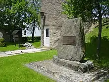
The declaration plaque on the summit remains and Buurgplaatz may still be erroneously considered the highest point in Luxembourg. [3]
References
- "US Gazetteer files: 2010, 2000, and 1990". United States Census Bureau. 2011-02-12. Retrieved 2011-04-23.
- "Le point culminant du Luxembourg".
- ACT (Administration du Cadastre et de la Topographie) Regional Map R1 Clervaux - Huldange 1:20000 (2003) shows 'Kneiff' at 560m and 'Buergplaz' at 559m.