Butternut Creek (Unadilla River tributary)
Butternut Creek is a 37-mile-long (60 km) river in the state of New York. It converges with the Unadilla River just downstream of Mount Upton. The creek has many fish for fishing dominated by largemouth bass, smallmouth bass, wall-eye, chain pickerel, rock bass, and yellow perch.
| Butternut Creek | |
|---|---|
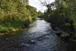
 Looking downstream from Bell Hill Road by Garrattsville | |
 Location of the mouth of Butternut Creek  Butternut Creek (Unadilla River tributary) (the United States) | |
| Location | |
| Country | United States |
| State | New York |
| Physical characteristics | |
| Mouth | Unadilla River |
• location | Mount Upton, New York |
• coordinates | 42°24′55″N 75°22′30″W |
• elevation | 1,000 ft (300 m) |
| Length | 37 mi (60 km) |
| Basin size | 130 sq mi (340 km2)[1] |
| Basin features | |
| Progression | Butternut Creek → Unadilla River → Susquehanna River → Chesapeake Bay → Atlantic Ocean |
| Tributaries | |
| • left | Stony Creek, Cahoon Creek, Shaw Brook |
| • right | Calhoun Creek, Morris Brook, Thorp Brook, Coye Brook, Dunderberg Creek, Halbert Brook, Dry Brook |
The Mohawk called the creek the Tienuderrah.[2] General Jacob Morris visited the area in 1787, and described Butternut Creek as "the handsomest navigable creek I ever lay my eyes upon."[3]
Tributaries

Stony Creek flows into the creek northwest of New Lisbon.[4] Shaw Brook flows into the creek south-southwest of Gilbertsville.[5] Cahoon Creek flows into the creek east of Gilbertsville.[6] Dunderberg Creek flows into the creek east of Gilbertsville.[7] Calhoun Creek flows into the creek southeast of Morris.[8] Morris Brook starts just east of Shacktown Mountain and flows south into Allen Pond. It exits Allen Pond and continues flowing south through Dimock Hollow before flowing into Morris Pond. It exits Morris Pond and flows southeast before converging with Butternut Creek southwest of Morris.[9] Thorp Brook flows into the creek northeast of Gilbertsville.[10] Coye Brook flows into the creek northeast of Gilbertsville.[11] Halbert Brook flows into the creek southwest of Gilbertsville.[12][13][14][15] Dry Brook flows into the creek southwest of Gilbertsville. Dry Brook was formally known as "Copes Brook".[16][17]
References
- "USGS 0150238005 BUTTERNUT CREEK AT MOUTH AT MOUNT UPTON NY". usgs.gov. United States Geological Survey. Retrieved September 3, 2021.
- Eddy, Hilah Violet (1926). The Lull Book. Detroit, Michigan. p. 20. Retrieved Oct 20, 2020.
{{cite book}}: CS1 maint: location missing publisher (link) - Morris, Jacob; Young, Hollis (ed.); Young, Debbie (ed.). "BUTTERNUTS CREEK, 12 MILE FROM THE UNADILLA". usgennet.org. Retrieved Oct 20, 2020.
{{cite web}}:|first2=has generic name (help) - "Stony Creek". Geographic Names Information System. United States Geological Survey, United States Department of the Interior. Retrieved 2017-06-03.
- "Shaw Brook". Geographic Names Information System. United States Geological Survey, United States Department of the Interior. Retrieved 2018-09-09.
- "Cahoon Creek". Geographic Names Information System. United States Geological Survey, United States Department of the Interior. Retrieved 2017-06-03.
- "Dunderberg Creek". Geographic Names Information System. United States Geological Survey, United States Department of the Interior. Retrieved 2018-09-09.
- "Calhoun Creek". Geographic Names Information System. United States Geological Survey, United States Department of the Interior. Retrieved 2017-06-03.
- "Morris Brook". Geographic Names Information System. United States Geological Survey, United States Department of the Interior. Retrieved 2018-09-09.
- "Thorp Brook". Geographic Names Information System. United States Geological Survey, United States Department of the Interior. Retrieved 2018-09-09.
- "Coye Brook". Geographic Names Information System. United States Geological Survey, United States Department of the Interior. Retrieved 2018-09-09.
- Wagner, Lloyd A. (1982). Drainage Areas of New York Streams, by River Basins: A Stream Gazetteer : Part 1, Data Compiled as of October 1980. U.S. Geological Survey.
- Eastern New York All-Outdoors Atlas & Field Guide. Sportsman's Connection. 2016-08-27. ISBN 978-1-885010-78-0.
- Smith, Stanley E. (1950). Manual for the Fisherman: A Practical Guide for Fresh and Salt Water Fishing. News Syndicate Company.
- "Halbert Brook". Geographic Names Information System. United States Geological Survey, United States Department of the Interior. Retrieved 2018-09-09.
- "Dry Brook". Geographic Names Information System. United States Geological Survey, United States Department of the Interior. Retrieved 2018-09-09.
- "Butternuts Town". historicmapworks.com. Retrieved 16 September 2018.