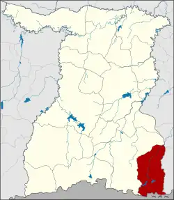
Buachet district
Buachet (Thai: บัวเชด, pronounced [būa̯.t͡ɕʰêːt]) is a district (amphoe) in the southeastern part of Surin province, northeastern Thailand.
Buachet
บัวเชด | |
|---|---|
 District location in Surin province | |
| Coordinates: 14°31′36″N 103°56′42″E | |
| Country | Thailand |
| Province | Surin |
| Seat | Buachet |
| Area | |
| • Total | 479.0 km2 (184.9 sq mi) |
| Population (2005) | |
| • Total | 37,877 |
| • Density | 79.1/km2 (205/sq mi) |
| Time zone | UTC+7 (ICT) |
| Postal code | 32230 |
| Geocode | 3213 |
History
The minor district (king amphoe) Buachet was created on 21 August 1978 when the three tambons, Buachet, Sadao, and Charat, were split off from Sangkha district.[1] At first a temporary district office was established at the base of the Patrol Police group of the area. It became a full district on 27 July 1984.[2]
Geography
The southern part of this district is in the Dângrêk Mountains.
Neighboring districts are (from the west clockwise) Sangkha of Surin Province, Khukhan, Phu Sing of Sisaket province, and Oddar Meancheay of Cambodia.
Administration
The district is divided into six sub-districts (tambons), which are further subdivided into 67 villages (mubans). Buachet itself has township (thesaban tambon) status and covers parts of the tambon Buachet. There are in addition six tambon administrative organizations (TAO).
| No. | Name | Thai name | Villages | Pop. | |
|---|---|---|---|---|---|
| 1. | Buachet | บัวเชด | 130 | 8,972 | |
| 2. | Sadao | สะเดา | 120 | 5,780 | |
| 3. | Charat | จรัส | 140 | 6,300 | |
| 4. | Ta Wang | ตาวัง | 150 | 5,878 | |
| 5. | A Phon | อาโพน | 160 | 6,365 | |
| 6. | Samphao Lun | สำเภาลูน | 170 | 4,582 |
References
- ประกาศกระทรวงมหาดไทย เรื่อง แบ่งท้องที่อำเภอสังขะ จังหวัดสุรินทร์ ตั้งเป็นกิ่งอำเภอบัวเชด (PDF). Royal Gazette (in Thai). 95 (89 ง): 2828. August 29, 1978. Archived from the original (PDF) on May 16, 2012.
- พระราชกฤษฎีกาตั้งอำเภอลานกระบือ อำเภอดงหลวง อำเภอทรายมูล อำเภอแม่เมาะ และอำเภอบัวเชด พ.ศ. ๒๕๒๗ (PDF). Royal Gazette (in Thai). 101 (96 ก special): 10–12. July 16, 1984. Archived from the original (PDF) on February 1, 2012.
External links